I quit my job and purchased a one way ticket to Manila, there was no turning back. Early 2017, our idea for a non-profit social enterprise called Fair Photo had gained a little traction. We were now a 7 team strong and one of the things that was left to do was gather more content and beneficiaries.
About a year I would travel to take photos and scout local NGO’s that could potentially receive benefits from the photographs that Fair Photo would sell. I just had no idea yet how to find these local NGO’s and even if I did, if they were interested in our project at all.
13 months of traveling, working, photographing and scouting NGO’s and projects followed. This is the first out of 3 parts that showcases some of the nicest or most interesting images of this journey. After all major images have been published, more detailed photo journals will follow that document the individual NGO’s and their locations.
The Philippines
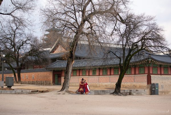
Manila
I didn’t quite understand yet why the hostel lady in Manila started clapping her hands of joy when I told her I wanted to go north, though the next few days in Manila – and the arrival north – made me understand a bit better. In Manila, the visit to the department of social welfare (to retrieve NGO recommendations for Fair Photo) was quite a lengthy nightmare of confusion with the conclusion being that I had to send a letter instead. Then, at night being rudely awakened by first an earth quake, then by a snoring large lady who made my bed shake more than the earthquake and finally by a repeatedly drunk-out-of-bed-falling elderly goatee-wearing man, which wouldn’t have been so bad until he started asking me if I had a problem with that.
Leaving north to the idyllic mountains escaping the urban wilderness that is Manila sounded more and more like a good plan… I just had to… leave? Apparently to the average Manileño not moving inside a car with air conditioning is still better than moving outside without, which sums up Manila traffic pretty well. All jokes aside, while I was skeptic about safety after seeing guards with guns at every store entrance, warm welcomes with genuine smiles were in vast abundance without ever really feeling unsafe for a second.
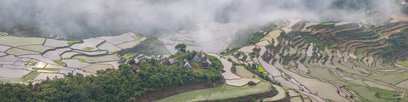
Batad
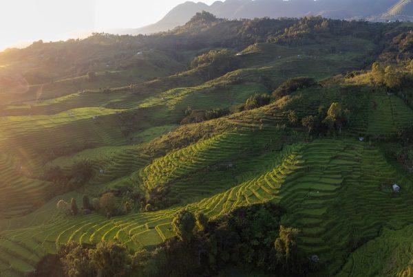
Going north, my first destination was Batad with its great amphitheatre of rice terraces.
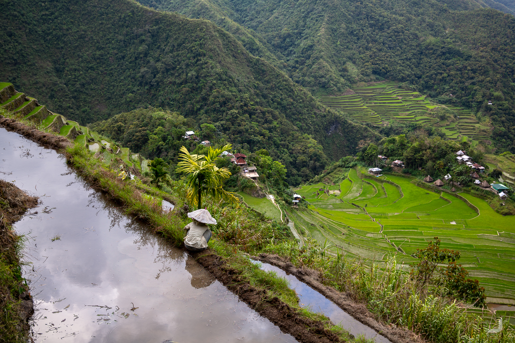
The people of Ifugao have been cultivating these terraces for many generations. The water comes from an ancient irrigation system that collects the water from the rainforests above the terraces. The wet season is from November to February and the terraces will be filled with water. Planting happens from February to March and from March to June it will become green like on the photo (April). Finally, the harvest happens between July and September which will give the terraces a golden glow.
Upon arrival in Batad a local Ifugao lady quickly convinced me to let her take me up to several viewpoints. So far the paths have been paved so I though it would be okay to wear my sandals instead of my hiking boots. The poor decision couldn’t become clearer after a bunch of kids were held up behind us. One of them couldn’t take it any longer and shouted out of frustration “you have such big feet and yet you are so slow!”. That was true, I had nothing to say to that.
After we came down from what turned out to be a sweaty hike up the hills I met a Filipino dad and his children who were intrigued by my mission for Fair Photo and offered me a ride to the next city of Sagada. At first, I politely refused. However, I bumped into them again in Banaue by chance on my way to the mayor’s office to ask for NGO recommendations for Fair Photo. They offered to join me to see if they could be of any help. Turned out it was a blessing because they helped translating in Tagalog. I felt less awkward to join them after our brief moment of collaboration and what followed were a couple of days of being part of a Filipino dad and his children’s holiday, sharing ghost stories, looking for a ‘forever’ for one of the kids, sharing a dorm room and getting up early to watch the sunrise. On the final drive the dad said that the best thing that happened on their holiday was.. .meeting me. True or not, he knew how to make the car fill up with one extra smile.
He dropped me off back in Banaue because I was interested in visiting the NGO called Rice Terrace Conservation Banaue that was recommended earlier at the mayor’s office. This NGO restores and maintains rice terraces in the Banaue region. Apparently, the most difficult part of a rice terrace is to get it started. Once it’s running it’s easier to maintain. When some rice terraces become decayed and the farmer is unable to restart it again, this NGO will take over and do the hard work of restoration instead. Afterwards, they either return it to the farmer or keep maintaining it with part of the profits going back to the farmer. All to preserve the rice terraces, which are decreasing in number every year.
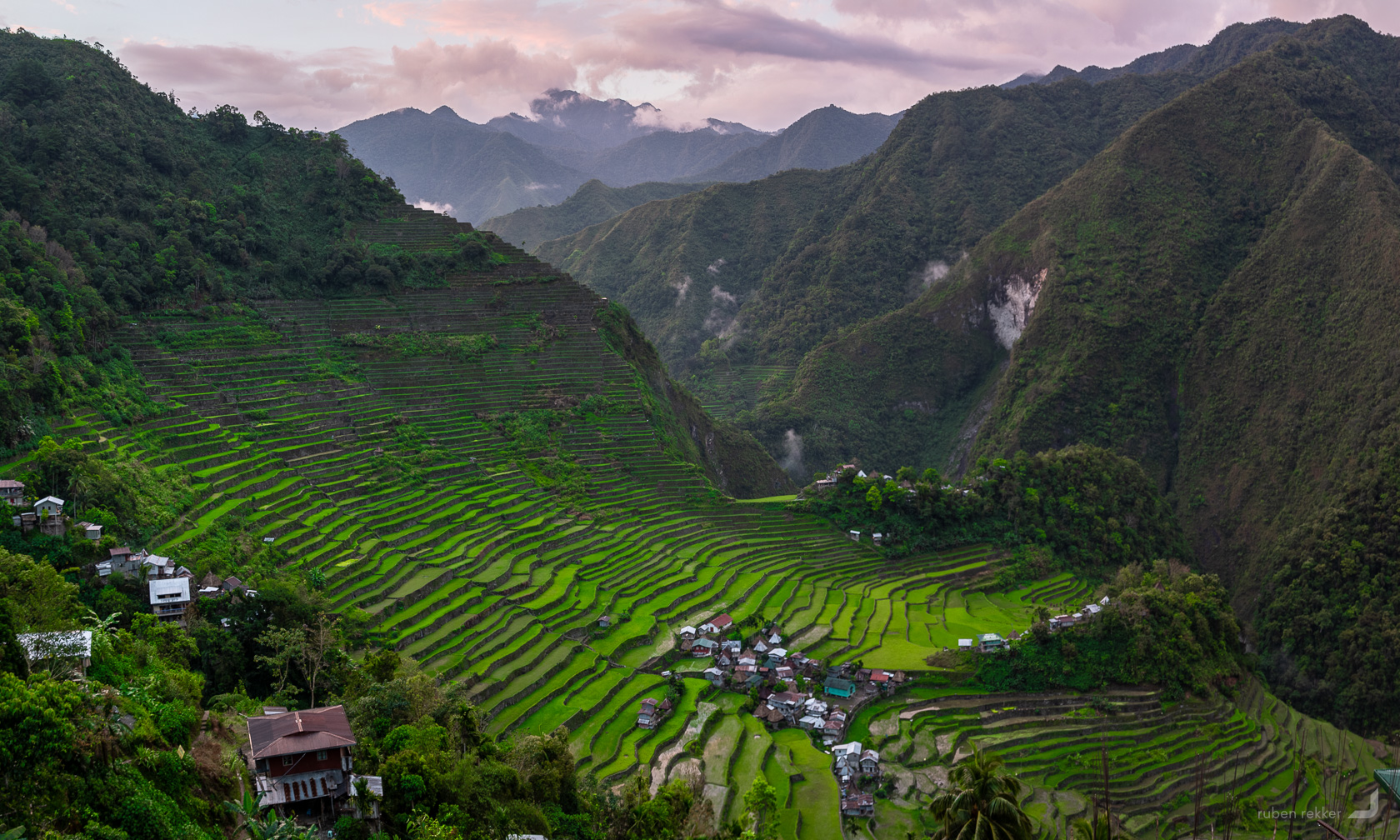
The view over the rice terraces in Batad, Philippines which has been listed on the UNESCO world heritage list since 1995.
Banaue
Back in Banaue a guy from Rice Terraces Conservation Banaue named John, took me to some of the rice terraces they are currently restoring. Along the path were a couple of elderly Ifugaos wearing traditional clothing who seemed eager to have their picture taken.
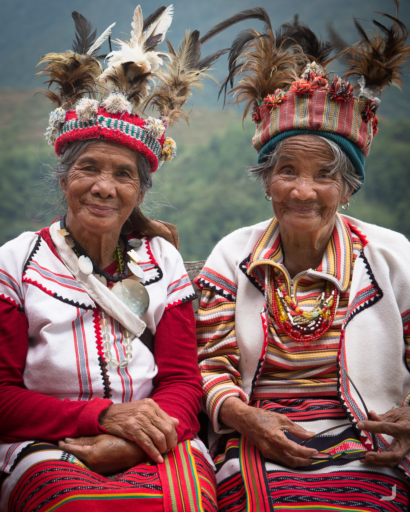
Two Ifugao women pose for the camera in Banaue, the Philippines.. The wraparound skirt that Ifugao women wear is called a tapis. There are five kinds and is worn depending on the occasion and/or her status. The men wear a g-string called wanno of which there a 6 kinds.
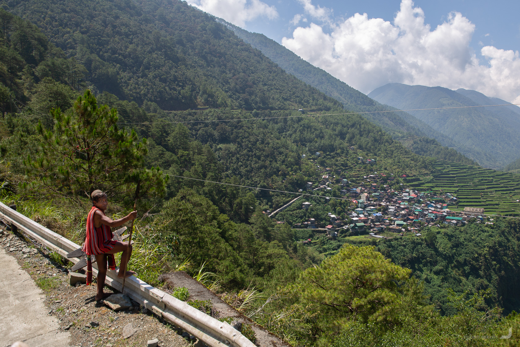
An Ifugao warrior looks out over the Bay Yo rice terraces in the Philippines. His environment has changed exponentially over the past decades.
I had heard about Whang-Od, an elderly lady living in Buscalan, who still practices tattooing the ancient way of her tribe. Being the last person who knows how to do this, she had risen to the top of well known persona’s in the Philippines. Her signature tattoo is three dots. Trying to take a portrait of her would be quite a story, though getting to her town could be quite a story on its own. I was warned from various corners that it could be dangerous. So my plan was to go only if I could find a couple of people to go with. It came down to the day of departure itself. If I could convince some people on the truck to Bontoc to come along to Buscalan then I would continue to go, otherwise I would divert my journey and visit a much closer town instead. On the truck, I happened to be accompanied by 3 Dutch interns who were on a short break from their work more north in the Philippines. They liked the idea of visiting Whang-Od and decided to join. We all got out in Bontoc (our driver received a fine for us traveling on the roof of the truck which we offered to split) and looked for the jeepney to Buscalan. It turned out that we had to wait till the afternoon before it would leave, which was too late for the Dutch guys so they changed their minds. With them continuing their trip to Sagada instead of Buscalan, I decided to take the jeepney to Maligcong, an nearby town also famous for its rice terraces.
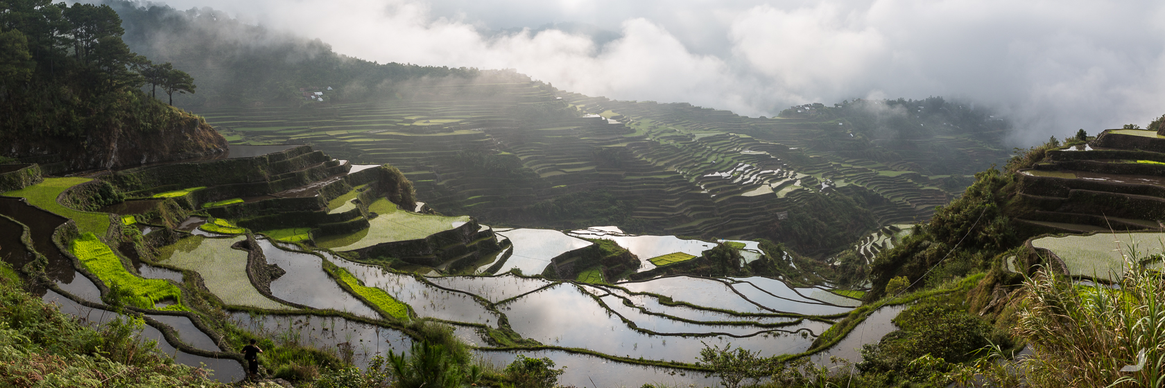
Maligcong
There is no set time when a jeepney leaves in the Philippines. They leave when they have enough people on board + when they feel like it. As I was waiting inside the jeepney to Maligcong, I was squeezed in between local Filipino’s and local vegetable bags. Two students in front of me were visibly in a hurry and said that they had to study for an exam they had at 3pm. It was 2pm now and it would’ve already been near impossible to make it. It did not matter. But we left eventually, and I got caught up in a conversation with the lady next to me. So much so, that I forgot to look at where I should get out. At some point the jeepney stopped with everyone inside looking at me (apparently it had stopped at one of the hostels called Suzette). I wasn’t quite sure if this was the right place to get out, though it was too late, my reaction was too slow and the jeepney continued. The jeepney stopped once more with a lot of heads looking at me again. I could see outside the word ‘Vilma’ painted on one of the houses. I recognised this from a friend who had told me about a hostel called Vilma. I got out, met Vilma in person, and luckily she had a bed for me.
The next morning, two other guests and I went on an early morning trek up Mt. Kupapey near the hostel. The peak looked out over the rice terraces of Maligcong that were still waking up, covered in cloudy blankets.
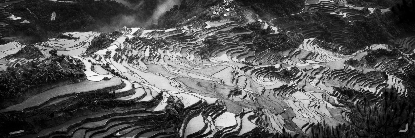
Rice terraces in Maligcong slowly clearing up from a blanket of clouds.
The Igorots who live in Luzon, the northern region of the Philippines, are known for their we-take-no-shit attitude. They were also known as head hunters (apparently they had cut off the last head in the 1970’s) and the advice I received was don’t piss them off and you’ll be alright. The guide who took us up the mountain told us a story of how two neighbouring tribes had several disagreements in the past. They were supposed to meet up here, pointing at a patch of grass, though one of the tribes didn’t trust the situation and had sent someone to have a look beforehand. They found out that a big hole was dug to lure them into a trap and they decided not to show up, avoiding a deadly confrontation. Thinking this was centuries ago, I asked the guide when this had taken place, he said late 00’s. Focusing back on the peace and serenity of the moment, the mountain scenery is breathtaking. I was told that a few years ago all these huts were still made of wood. Times were changing exponentially.
View from Mt. Kupapey over the rice terraces in Maligcong in the north of the Philippines.
Wherever I would walk amongst the terraces and I would see a local, or rather, when a local would see me, the local would approach me and ask how I was doing. At first, I was a little defensive and wondered whether they wanted something from me. Though later I learned that it was more a sign of care and I started to counter engage with as much energy as they gave me.. and walking life became better with the genuine smiles that followed.
Morning sunrise over the rice terraces in Maligcong.
Zambales
Ever wondered what a mountain would look like if you would cut it open? Wonder no longer if you pictured that in Zambeles and if it’s mostly made out of ash. Welcome to Mount Pinatubo.
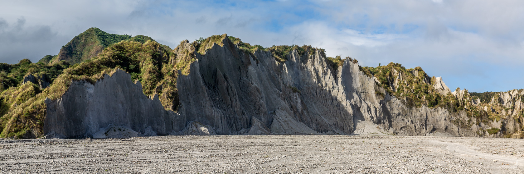
Mt. Pinatubo is an active volcano located in the south of Luzon. It erupted in 1991, which was one of the largest eruptions of the 20th century. Roads and hills such as these consist predominantly out of ash.
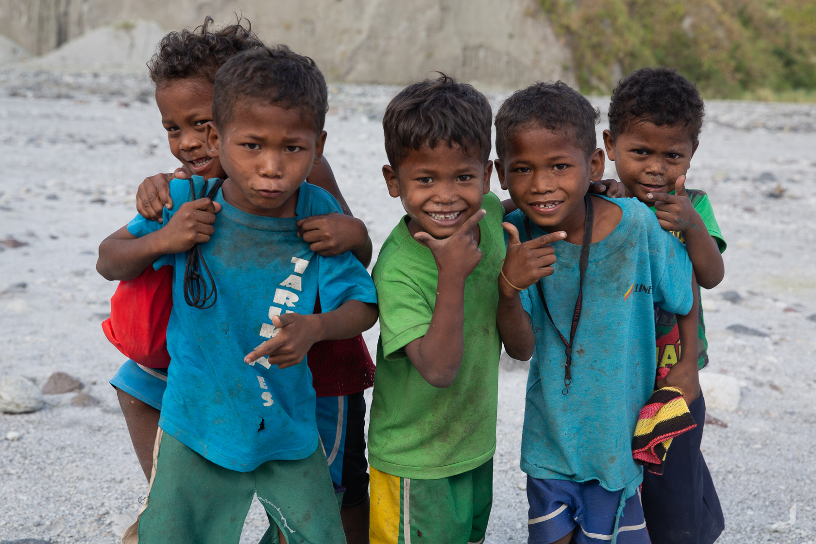
The Aeta people inhabit the surrounding lands and wherever we stopped local Aeta children would run towards us to try to sell bananas. They have less rights than other Filipino’s and are passive aggressively oppressed.
El Nido
Heading to El Nido, in the north of Palawan, an island located in the mid-west of the Philippines. It has the largest protected maritime area in the Philippines and is famous for white beaches, marble and limestone cliffs peaking out of the water and coral reefs.
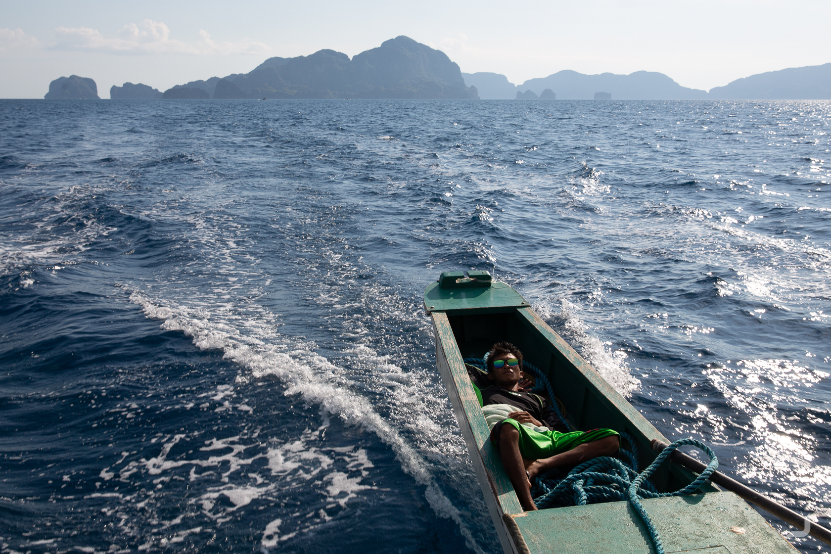
One of the skippers taking a break in the stern of the “pambot”, the typical Filipino “pump boat”.
In the mountains of Luzon it was fairly cool with temperatures dropping to 15 degrees Celsius at night and sporadic adventurous tourists could be spotted. El Nido however was rather a big step towards the tropical white sandy beaches I had imagined the Philippines mostly to be surrounded by. Although not as touristy as Boracay, there were still more puti (or foreigners) in this small town than I had seen in the whole of the north. At sunset, a more quiet spot could be found with a pambot in the distance.
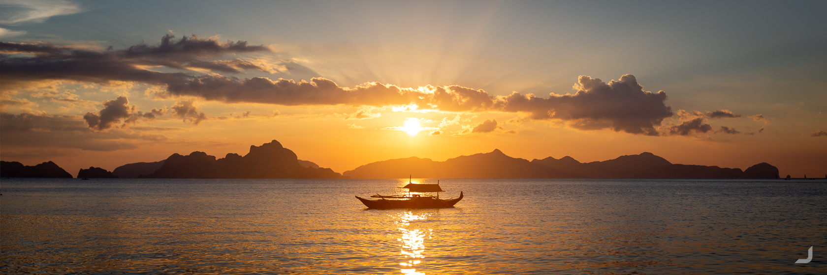
Looking out over the Bacuit Bay at El Nido.
Boracay
Spending a few days on the touristy island of Boracay, little gems of serene beauty are getting sparser as the island develops at record speeds. So much so, that the sewage system could no longer handle the amount of waste and had commenced directing it at sea. A temporary closure to tourists of 6 months should help the island recover.
-
Floating Rock
Philippines

Ocean view at Boracay island.
Cebu
Don’t (always) trust Google. If there is one lesson from this trip it was that. I checked the day before how to get from the hotel to Osmena peak on Cebu Island on Google Maps – and to make it in time for the sunrise we’d have to leave around 4am.
The road to Osmeña Peak on Cebu island.
The road we followed obediently slowly turned smaller, bumpier and steeper every meter that we traveled. It became so bad that kilometers turned meters until we could hardly move at all because of the bumps and rocks. Then imagine it going steep upwards, then add pitch darkness. When we fell from the bike for the third time, and the bike kept falling down, we decided to give up and turn back. Back at the main road, it was slowly getting light and we were able to ask locals how to get to Osmena peak. They directed us through the main road instead and we arrived, though not in time for the sunrise, but at least in one piece.
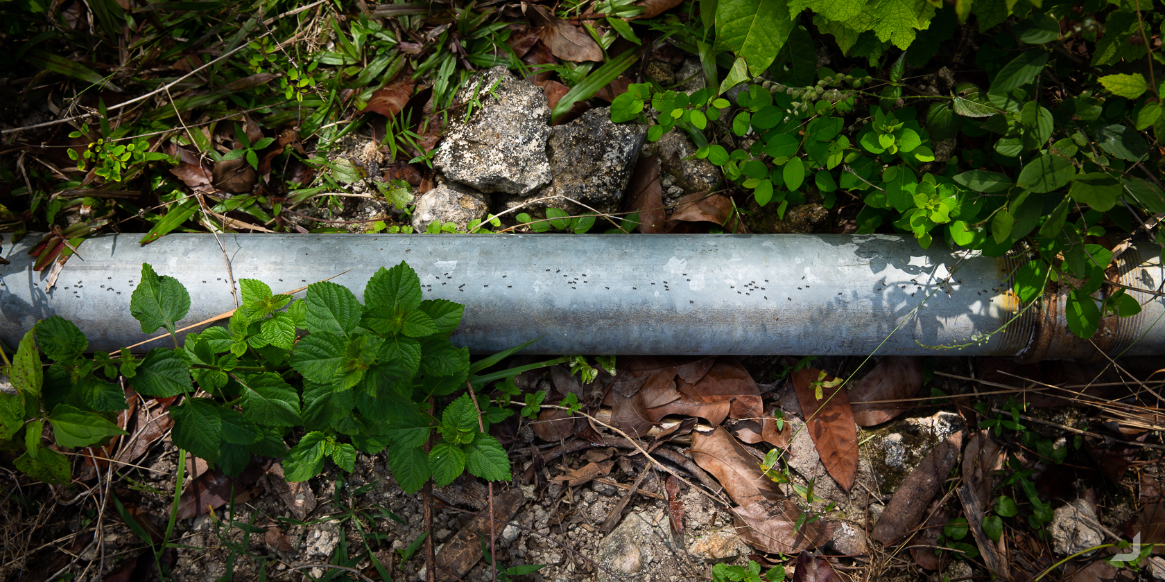
I often seek for views that stretch out over vast distances and convey a sense of grandness. Though sometimes (probably after another failed attempt to capture the uncapturable) I look down and see something I didn’t quite expect. This time it was a trail of ants that seemed to travel extra fast over their very own kindof ant super highway.
Singapore
I had a quick stopover in Singapore before continuing to Vietnam. It has a tiny park called MacRitchie Reservoir, that has a trail called the MacRitchie trail, that has a lonely Macaque monkey chilling in the sun. The population of long-tailed macaque’s in Singapore reaches about 1500 and once they have reportedly used human hair to floss.
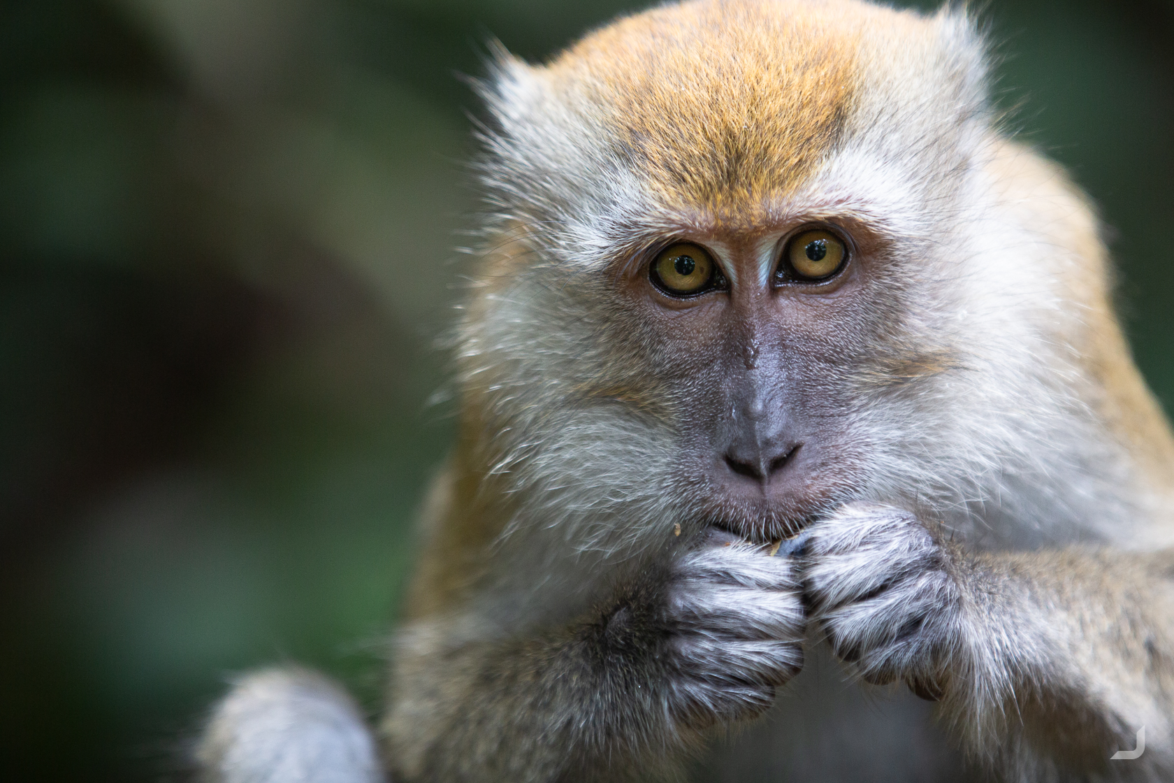
Long-tailed macaque in the MacRitchie Reservoir in Singapore.
When I tried to photograph the following dragonfly at the end of the trail, I couldn’t quite see what I was shooting at, neither if it was in focus or not. Coincidently it turned out that it was.
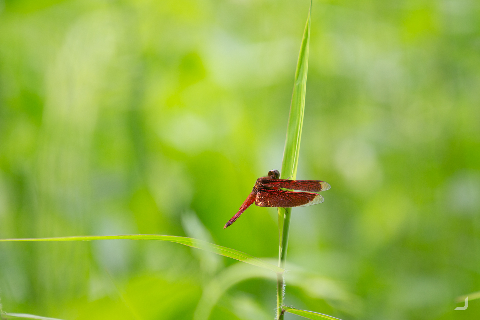
The male nomad dragonfly, aka red veined darter can be found in the regions of Europe, North Africa, Middle East and Asia.
Stopping by at Singapore Zoo.
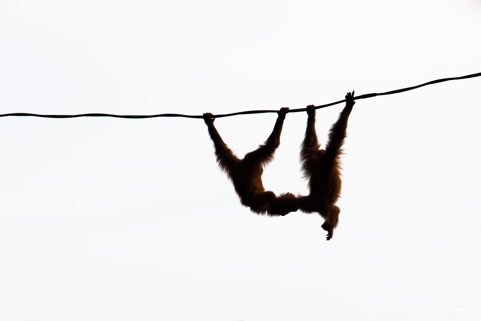
“Orang” and “hutan” are Malay words for “person” and “forest”. The orangutans are the only great apes of Asia and live in parts of Borneo and Sumatra.
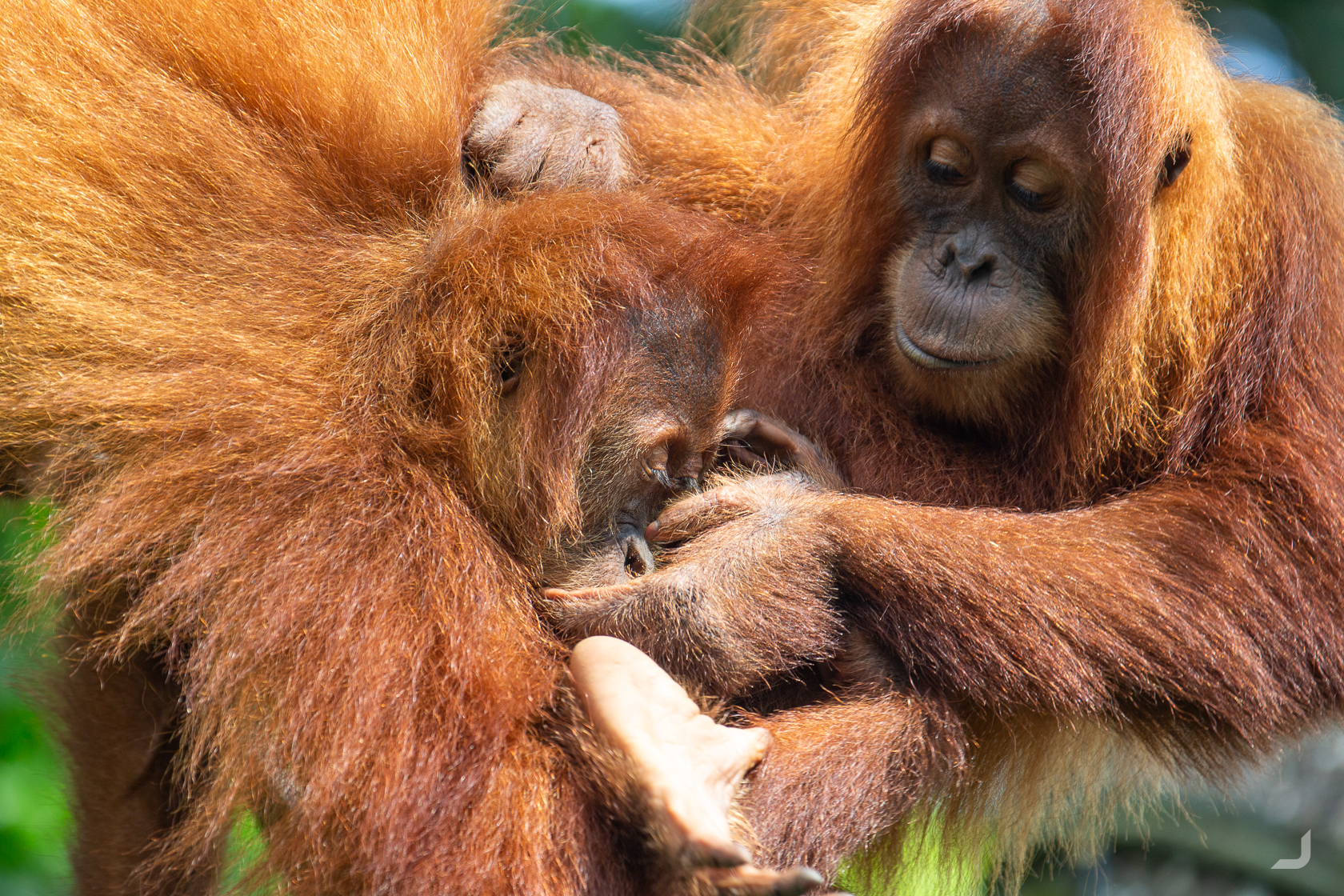
Watching these orangutans up close makes one realise how human they really behave. Their natural habitats are aggressively being cleared to make room for agriculture, the most impactful being palm oil plantations. They have lost half of their habitat since 1994 (WWF).

Thinking this was an albino peacock at first, I noticed later that the eyes were actually dark, most likely making the condition leucism. He jumped on stage after a presenter had finished his talk and promptly and proudly showed off his great white feathers, as if he had been patiently waiting for this moment all along.
The Supertrees in Singapore, located in the Gardens by the Bay, were part of a nationwide push to enhance greenery and flora in the city and has become a major tourist attraction since. The “trees” mimic ecological functions of real trees; photovoltaic cells harness solar energy that is partly used for its lights at night and it collects rainwater that is used in irrigation and nearby fountains.
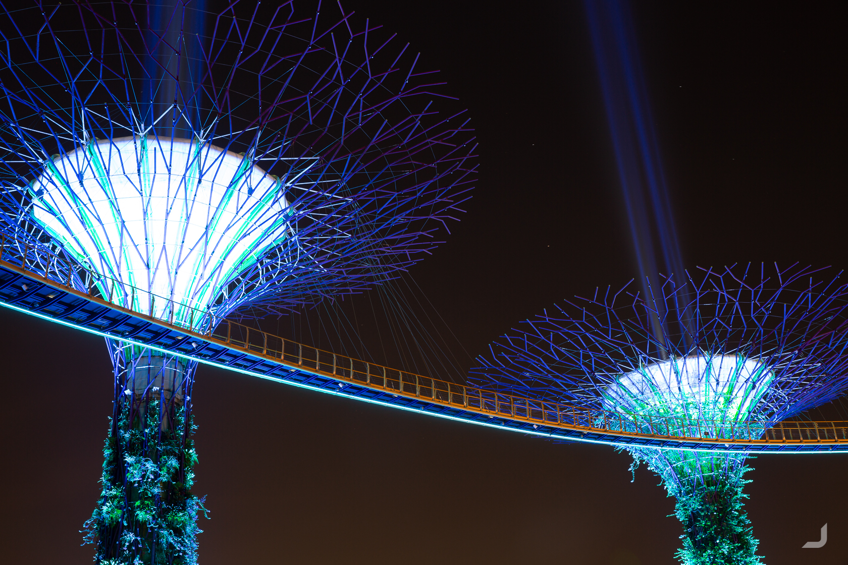
“Supertrees” in Singapore.
Celebrating my 33rd birthday in a bar called Level 33 on the 33rd floor. A friend told me it means I was exactly where I had to be in life. No idea if I truly was but it was a beautiful thought nonetheless.
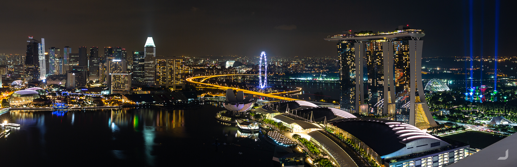
Marina Bay from the 33rd floor of MBFC Tower 1.
Vietnam
Ho Chi Minh
I returned to Vietnam to work on Fair Photo’s website for a month or two. It’s cheap, the food is great, the internet is fast and there is plenty of salsa to dance. Clearly remembering the culture shock I had 5 years ago – being surrounded by swarms of motorcycles (and almost no cars), the humidity, the smell, the overhanging power cables, the bars with yelling ladies – however all this actually strangely felt a bit like coming home this time around. There were now also plenty of more cars than motorcycles compared to last time, Vietnam seemed to have been developing fast.
The Saigon river that flows through Ho Chi Minh is lit up by a set of massive billboards that face the city. Combined, they feature an enormous ad for a Dutch beer company. Where they are actually placed is a popular spot for couples to hang out. The backsides are covered in ads from the government, though not facing the city neither lit up.
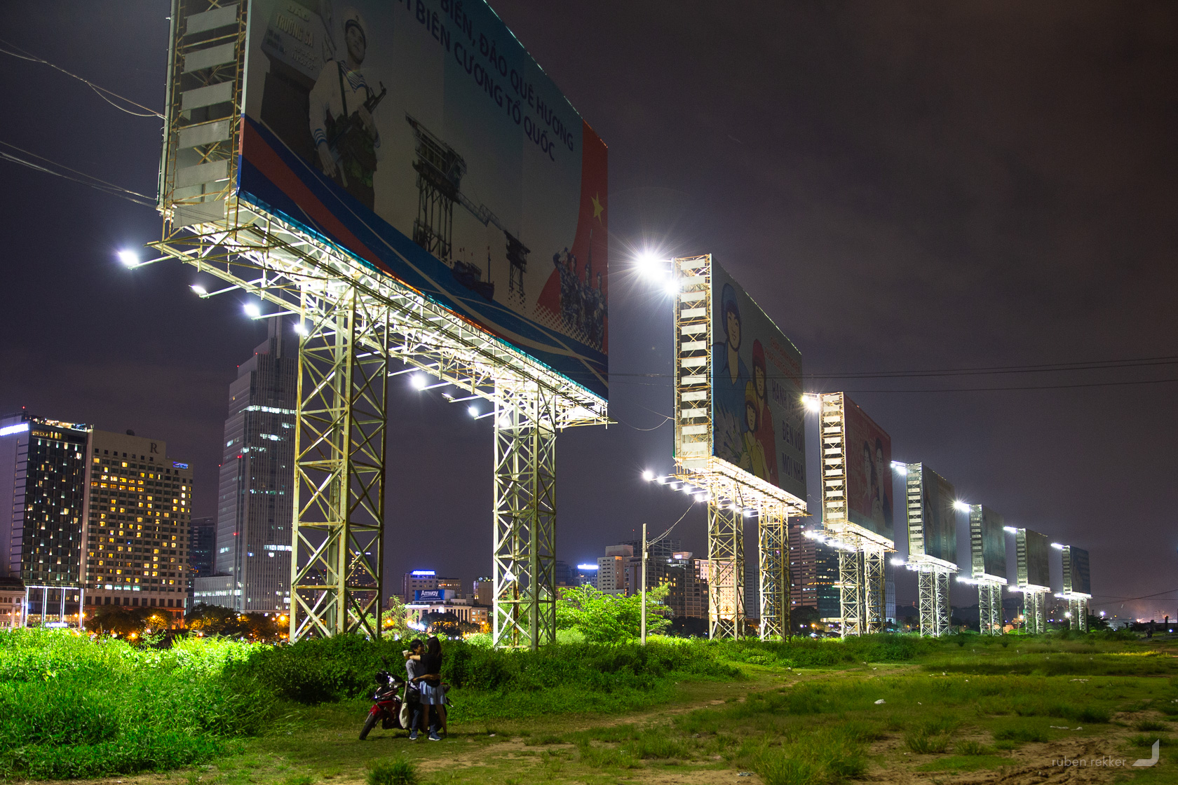
A couple gathers below massive billboards in Ho Chi Minh, Vietnam. Each billboard features an enormous ad for a Dutch beer company and overlooks the Saigon river, facing the city. The backside show ads from the government.
Mui Ne
Leaving to Mui Ne for a couple of days. The dunes in this small town in Vietnam look like a tiny Saharian desert along the coast.
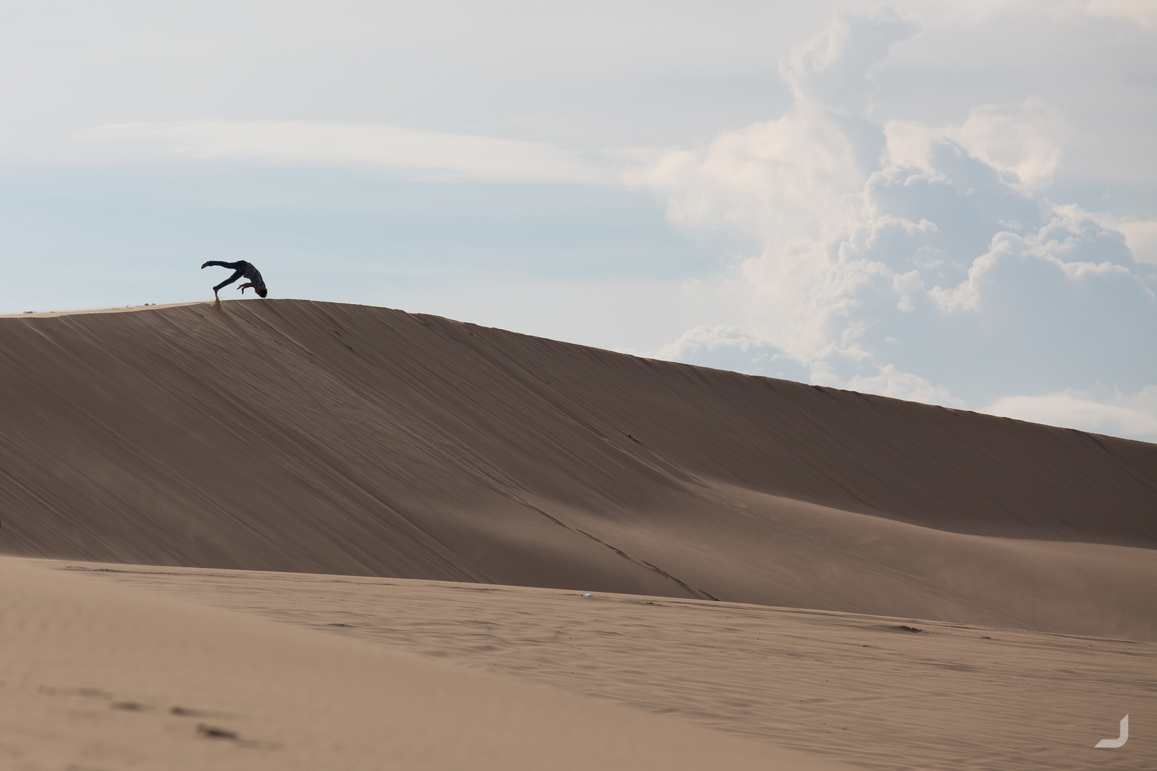
A local decides to jump down head first in the dunes of Mui Ne.
When stepping down the dunes in Mui Ne, sand almost behaves like water.
Bau Trang (white lake) is a lake that’s located alongside these dunes. You can see the effects of the wind on two different surfaces right underneath each other providing for an arty perspective.
-
Ripples
Vietnam

Contrasting water vs sand near the Bau Trang lake.
Amongst the sand some sporadic vegetation could be found. Along with the sand it visualises what the draft from the wind actually looks like.
-
Turbulence
Vietnam

A trail of sand altered by the winds is visualised behind this small bush.
Ho Chi Minh
Most of the tall (residential) buildings in South East Asia still appear to have virtually no restrictions on entering their rooftops. The view of my temporary residence near the Rach Bến Nghé river expresses how densely certain patches of urban jungle in Ho Chi Minh are built.
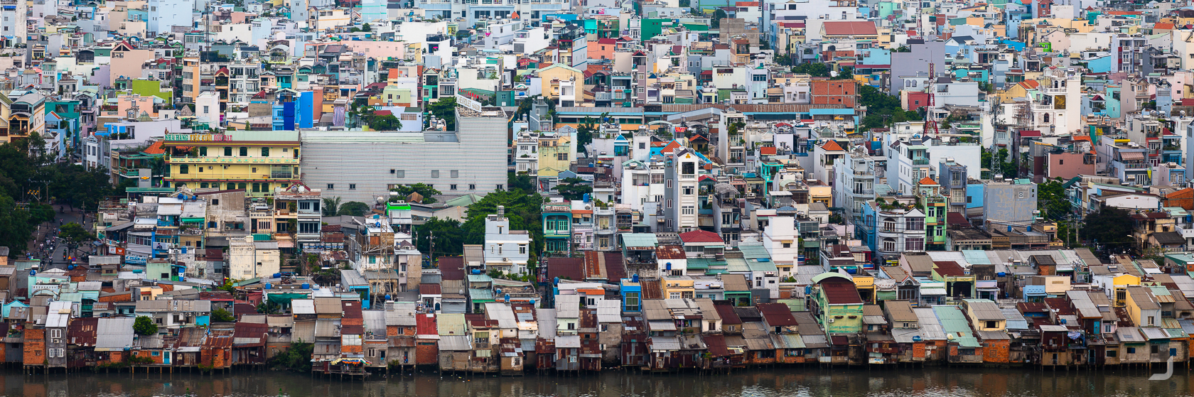
Rows of houses along the Rach Bến Nghé river in Ho Chi Minh, Vietnam.
A busy street in Ho Chi Minh using the bokeh effect (purposely out of focus).
Hội An
I had to return to the historical town of Hội An to find a local NGO that could become a beneficiary for a photo I took in 2012. When I arrived I was in for a surprise (read shock) by how much had changed. One of my favourite quiet towns in Vietnam seemed to have turned into a busy mini metropolis. Though late at night most of the crowds withdrew to their respective hotels and one had the opportunity to wander along the riverside without the sea of people colouring the promenades.
Beautiful Hội An has a long history of trading. Shipwreck discoveries revealed that Vietnamese and Asian ceramics were transported from Hội An to as far as Egypt. Much of the architecture and infrastructure still reflects this history today.
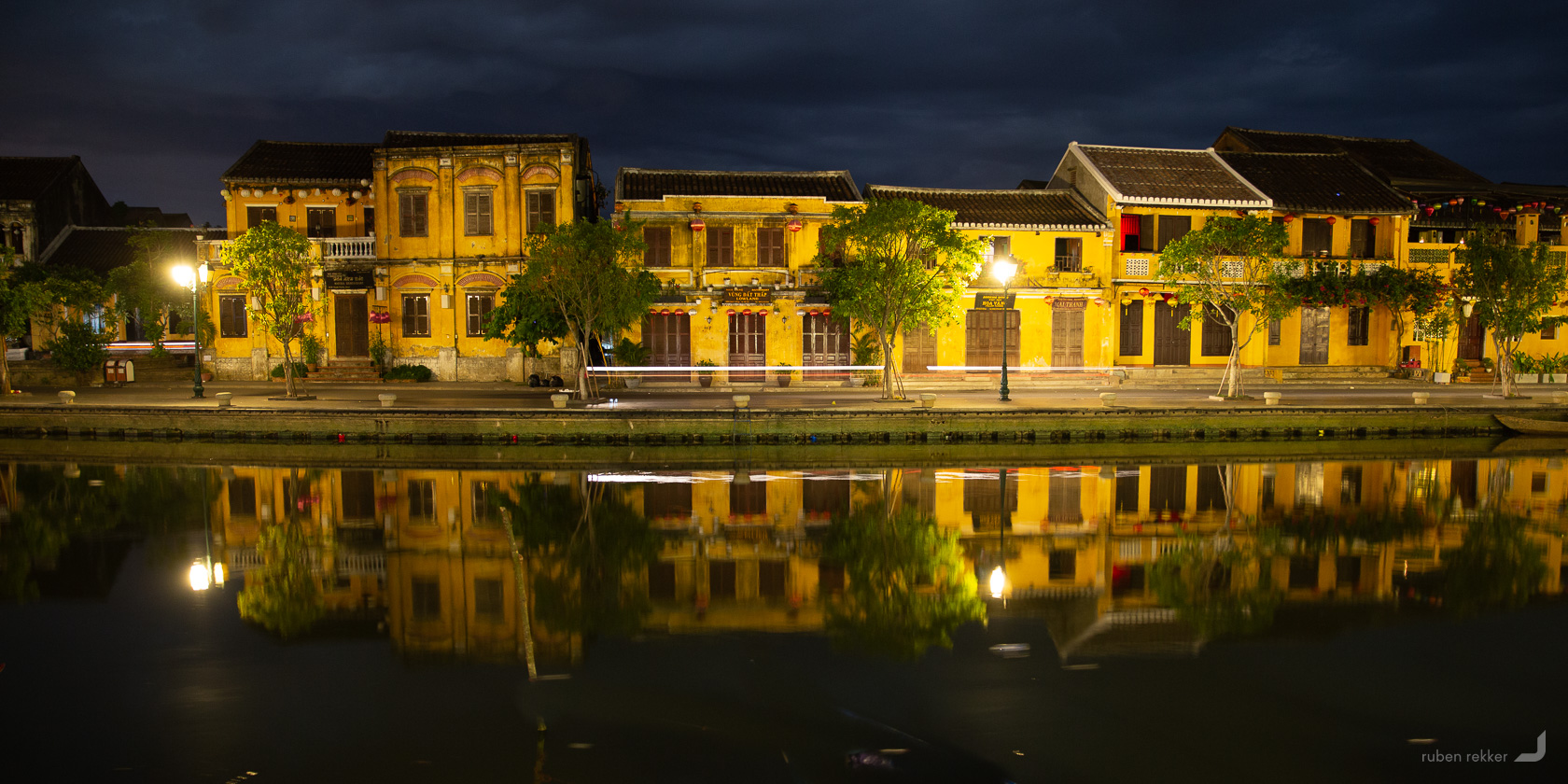
Ancient houses along the Thu Bồn river in Hoi An at night.
Myanmar
Yangon
Returning to Myanmar to visit a local NGO called Hnalone Hla Inn Maung Mae, to document their activities for Fair Photo, together with a friend. We would shoot a short documentary video that would assist Fair Photo in selling an art photo that was taken in the same area in 2016. Before we traveled up to Inle Lake where the NGO is located, we had some time to spend in Yangon.
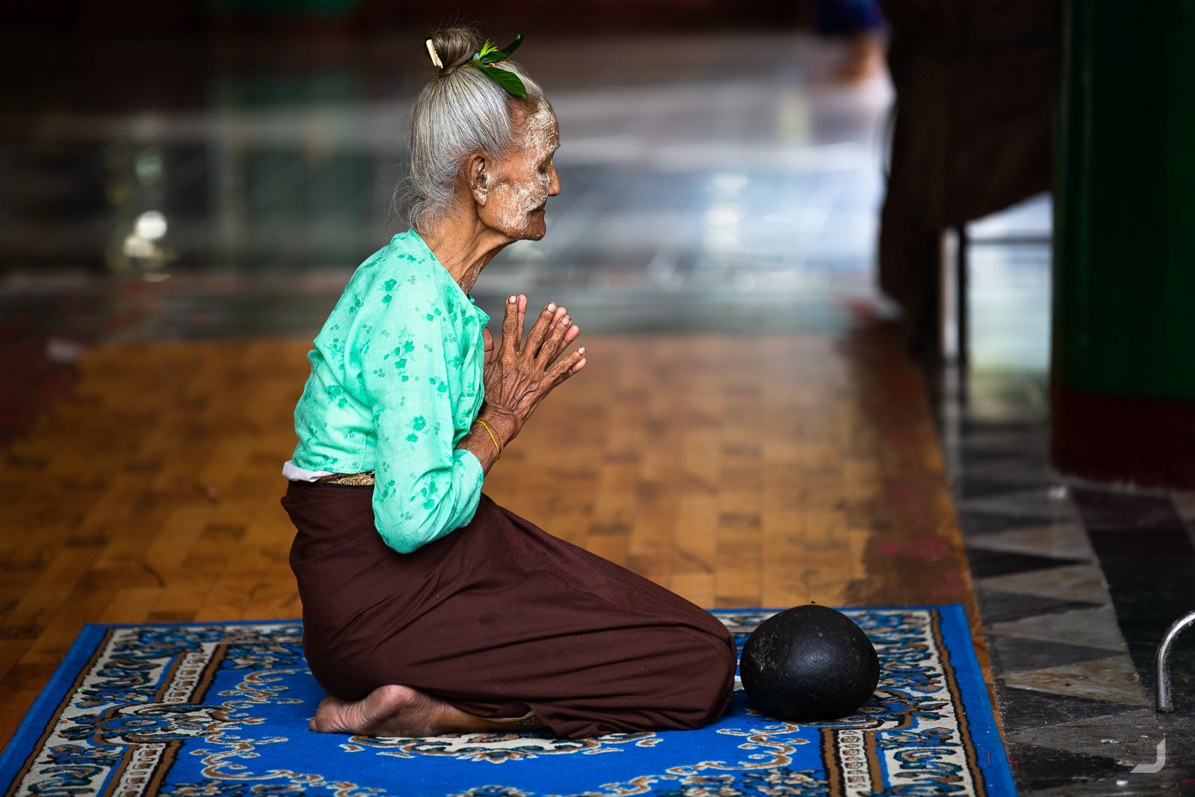
An elderly lady prays inside the Shwedagon Pagoda, the most sacred Buddhist pagoda in Myanmar.
In Myanmar, boys as young as 7 can join the monastery and start to study the teachings of Buddha. Sometimes as a voluntarily chosen path by their family, but many times out of a necessity; to receive free education, food and shelter.
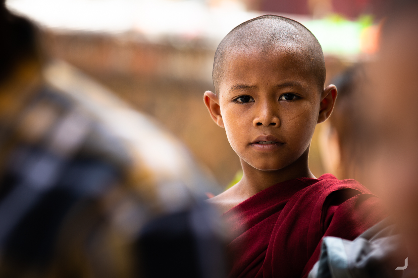
A young monk visits the Shwedagon Pagoda in Yangon, Myanmar.
Inle Lake
Inle lake is Myanmar’s second largest lake and is also one of the highest. The local Intha people fish for a species of carp, nga hpein, which is a staple for their local diet. The west side is also used for floating agriculture.
Two members of the local organisation Hnalone Hla Inn Maung Mae, Kyaw Thet Nain and Thu zar khine, took us here as part of their mini tour. They also introduced us to their families who live inside one of these houses on the lake.
The lake provides a livelihood to nearly 200,000 people but is suffering from overfishing, pollution, logging and a decrease of water volume. Hnalone Hla Inn Maung Mae teaches and works with locals to conserve the lake. Read more about them on their facebook page https://www.facebook.com/Hnalonehla-Innmaungmae-801233396596587 or view the Fair Photo here www.fairphoto.com/gallery/hanchank-nyi-chin.
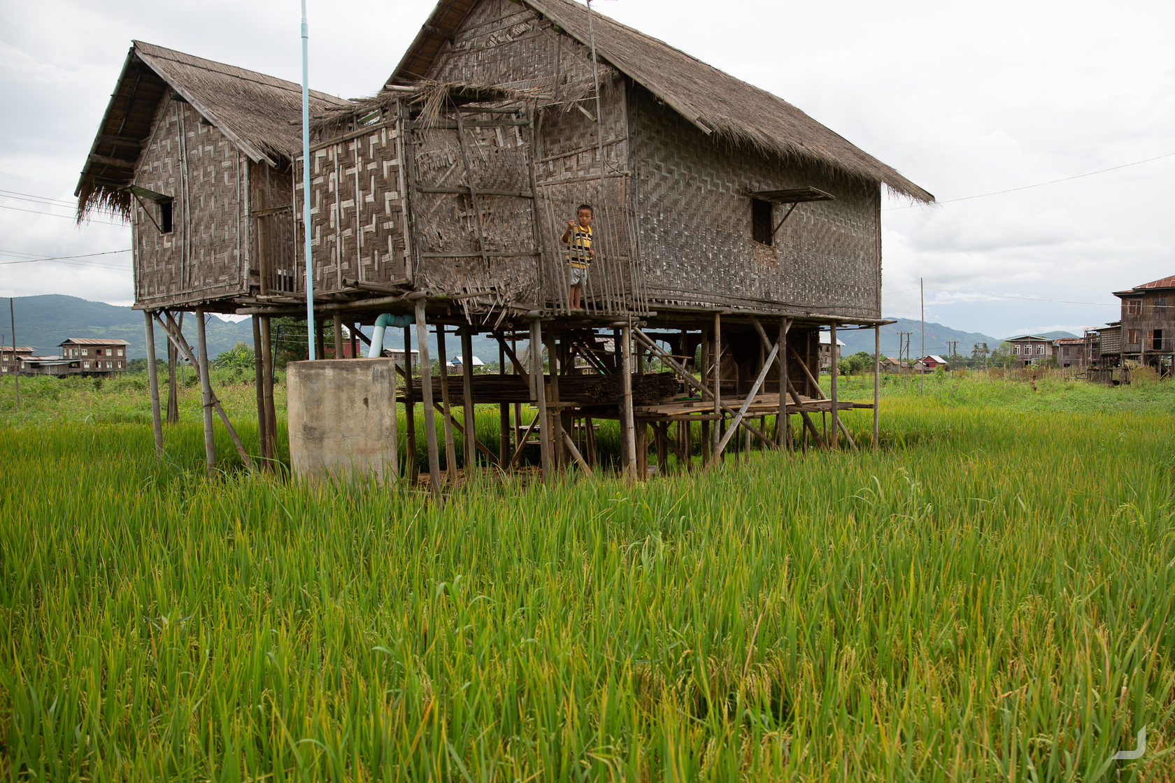
One of the many local houses built on stilts on Inle Lake in Myanmar.
Bagan
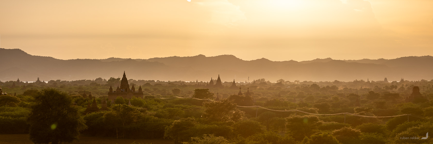
About 13,000 temples once coloured the plains of Bagan, in a small space of only 42 sq km. Most built between the 11th and 12th centuries, the golden age abruptly ended when Anawratha’s kingdom was invaded by the Mongols in 1287. Around 2200 still remain today, which still provide for a great challenge to find the perfect photo spot.
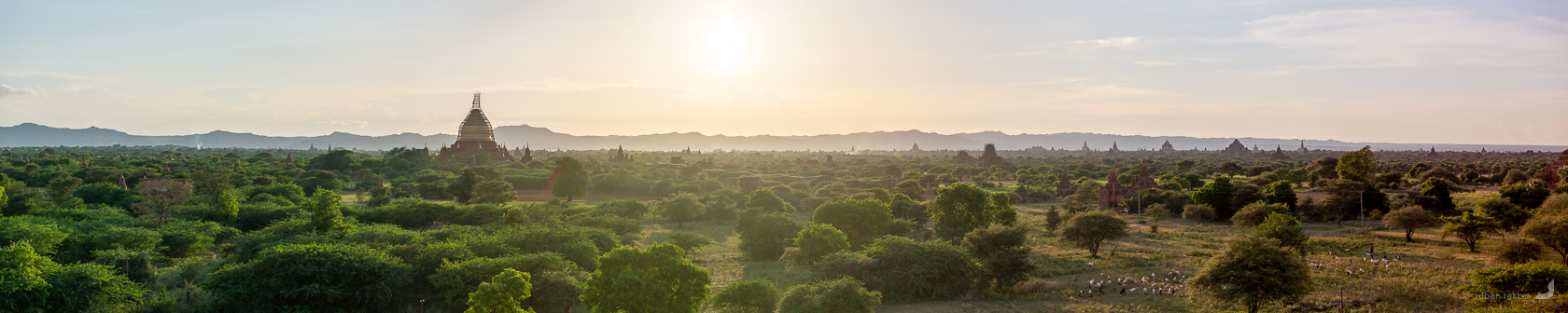
Around 2200 temples and pagoda’s still remain today on the plains of Bagan.
The Ayeyarwady river originates from Tibetan springs and Himalayan glaciers and roughly translates to “river that brings blessings to the people”.
The sun sets behind the Ayeyarwady river in Bagan.
The Ayeryarwady river is used in many ways and resembles hope to the Burmese people with its fertile soil, provision of drinking water, keeping their clothes clean and way of transport.
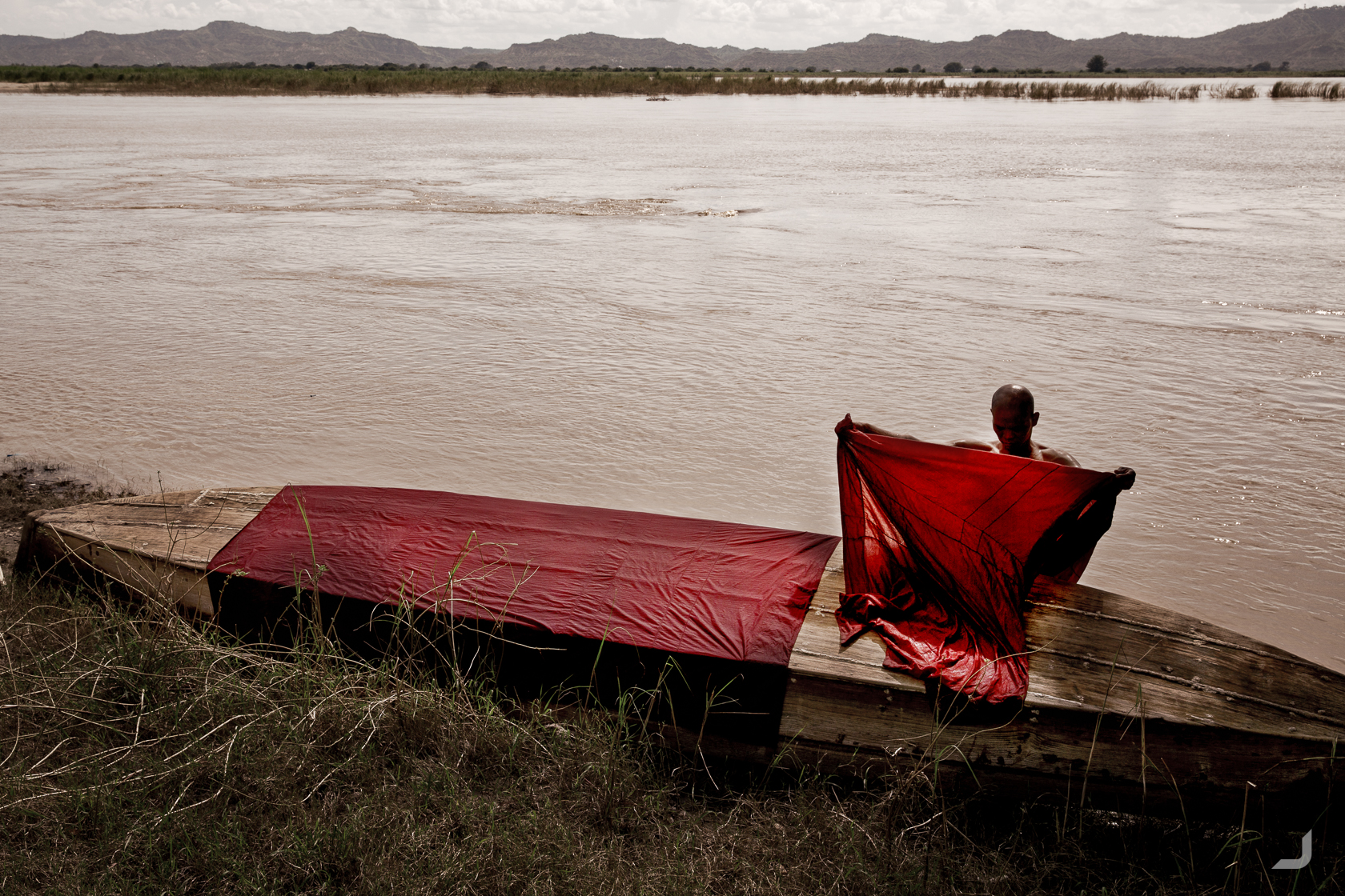
A monk dries his maroon coloured robe after washing it in the Ayeyarwady River that runs through Bagan, Myanmar. The Ayeyarwady river originates from Tibetan springs and Himalayan glaciers and roughly translates to “river that brings blessings to the people”.
Thailand
Bangkok
A stopover in Thailand to stay and work for a few weeks. While visiting the Grand Palace, I was intrigued by the immaculate patterns of the tiles on the rooftops. The halls and buildings inside the Grand Palace were added over a period of 200 years since 1782 by the order of king Phutthayotfa Chulalok (Rama I).
-
Grand Palace
Thailand

Colourful tiles on one of the many buildings inside the Grand Palace in Bangkok.
Staying in an apartment that once again had no restrictions on going to its rooftop. With Thong Lo train station pictured below in buzzing Bangkok city, it’s possible to get a sense of how dense and active the urban heart of the city is.
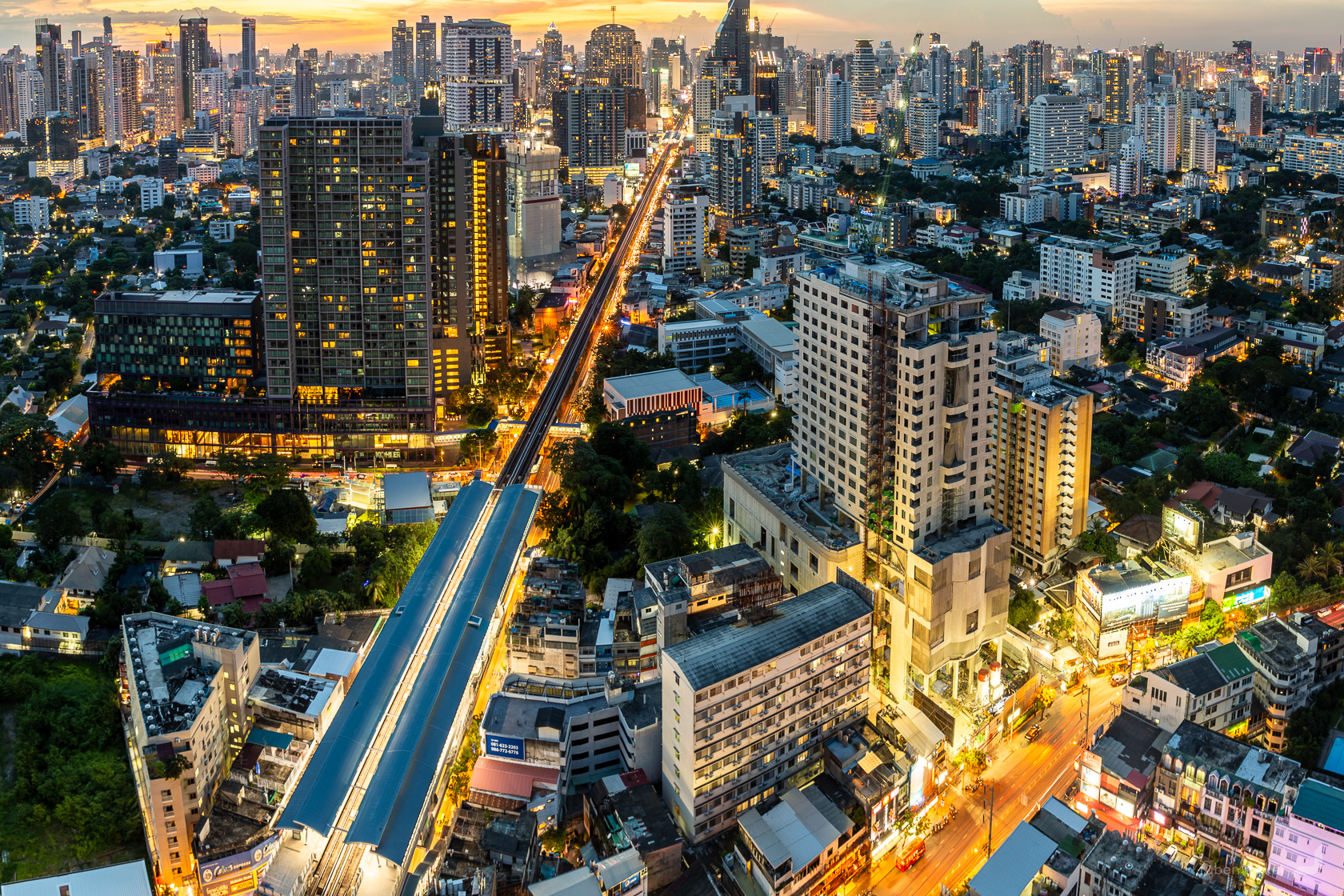
Thong Lo train station in Bangkok.
The Philippines
Cebu
From Myanmar, with a stopover in Thailand, back to the Philippines to visit NGO’s I was unable to visit the first time around. I had heard about an NGO up north of Cebu. But before I could go up, I would stay put in Cebu city to work for a couple of weeks. The decision to stay in Cebu became slowly a little more regretful. The city was quite polluted, there wasn’t much to see in the city itself and I had failed to really connect with anyone. The days slowly became lonelier and lonelier.
I had found a vegetarian restaurant about a 10 min walk from the hostel, where I had started going to almost everyday and there was always a small group of homeless elderly people sitting along the footpath underneath a self-made shelter. They would wave and call something out in Tagalog every time I passed by, but their serious looks had made me feel a bit weary un reluctant to respond. After a few times of ignoring them, I started waving and smiling back feeling like I had a little less to loose. They waved and called out as usual, but now with smiles like they were my best friends. In hindsight, with those people I might have had the realest connection out of all people I had met in Cebu for those weeks.
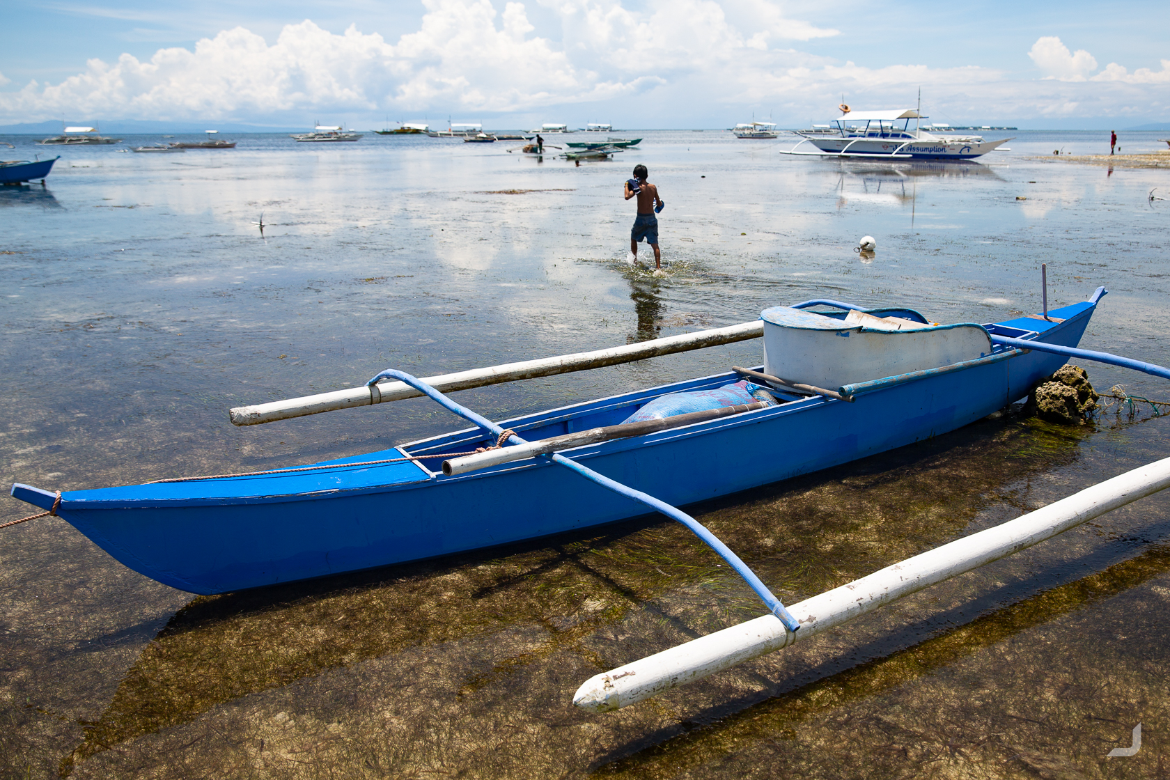
Malapascua
I had received word of an NGO called People and the Sea in Malapascua, a small island north of Cebu, and I started making my way up. After my arrival, I was guided to my room that was underneath a bigger house that turned out to be inhabited by the people who run People and the Sea. They were more than welcoming and you can read more about my experiences here https://www.facebook.com/groups/fair.photo.
Exploring the island I walked into this pambot, or pump boat. It is the go-to boat for nearly everything in the Philippines and you can find these nearly everywhere.
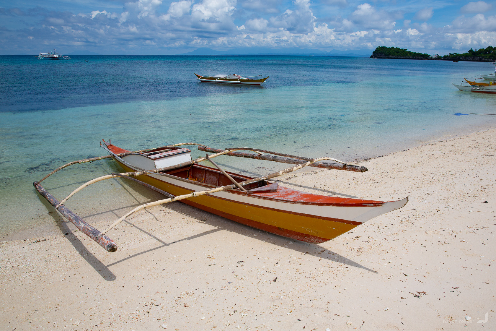
Several docked pambots in Malapascua, Philippines.
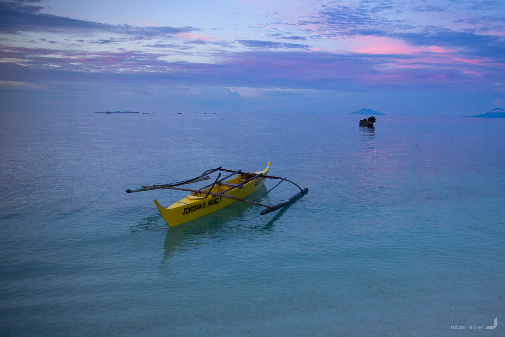
Pambot at dawn in Malapascua.
-
Old Pambot
Philippines

An old pambot along the beach in Malapascua, Philippines.
Bohol
The first time I had heard about Bohol was when an English couple in Batad tried to help me find local NGO’s by trying to remember initiatives that they might have passed on their travels. They mentioned a local kayak company that was operating on the island of Bohol, that was slowly seeing its beloved river of mangroves and fireflies disappear, largely due to the damaging impact of a competing motorboat tourist company. I traveled down to take a visit.
The fireflies in the mangroves are an indication of its health and unfortunately every year there are less and less fireflies present, presumably caused by the increasing amount of waves and wash generated by the motorboats, slowly eroding the mangroves. The boats carry tourists who all want to take a peak at these tiny wonders of nature, without the trouble of paddling in a kayak. Unfortunately there was not much the kayak company could do. “The motorboat company’s owner is friends with the mayor,” my guide said. But it’s not just the motorboats that add to the degradation of the mangroves, also the increase of tourism has seen closer roads built and the increase of social media has seen an ever increase of flash photography.
Light is pteroptyx macdermotti’s primary method of communication, it’s how they find a partner. The more light there is, the harder it becomes to communicate – thus the harder it becomes to find their “forever”. They don’t have a whole lot of time to find the ‘one’, about a month of shining on the aerial dance floor before their time is up.
Currently awaiting a strategy from Kayak Asia on how best to protect these mangroves whereas Fair Photo might be able to help.
-
Fireflies
Philippines

Fireflies along the mangroves of Bohol in the Philippines.
Scouting the surroundings of east Bohol, there was a shallow stretch of water near the beach of Momo with an abundance of parked pambots and activity.
The coast at the north east side of Bohol.
-
Palm Leaf
Philippines

A palm leaf covers Momo beach in the east of Bohol.
Towards the middle of the island, conical hills covered in grass stand out quite remarkably in contrast to the jungle forest below. In the dry season the grass turns chocolate brown, hence the name “Chocolate Hills”. I was there just a month before the dry season was about to start so it still rather looks a bit green.
Underneath the grass are karst hills that were partly pushed up and fractured due to tectonic processes and polished up by rain and wind. There should be as many as 1,268 to 1,776 hills on the island (cheers, wiki!).
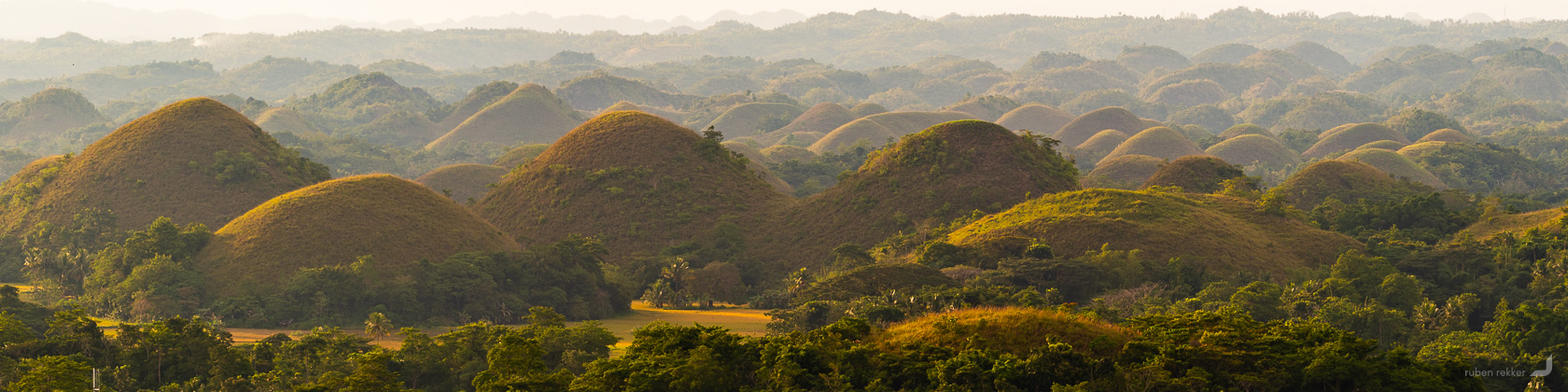
“Chocolate hills” in Bohol.
Zambales
Returning to Santa Juliana in Zambales to visit the organisation Health and Development for All, who help local Aeta children with food, medicines, accommodation and school supplies.
We explored several villages to document these people, view a glimpse of this trip here: https://www.facebook.com/media/set/?set=oa.594701104204988&type=3.
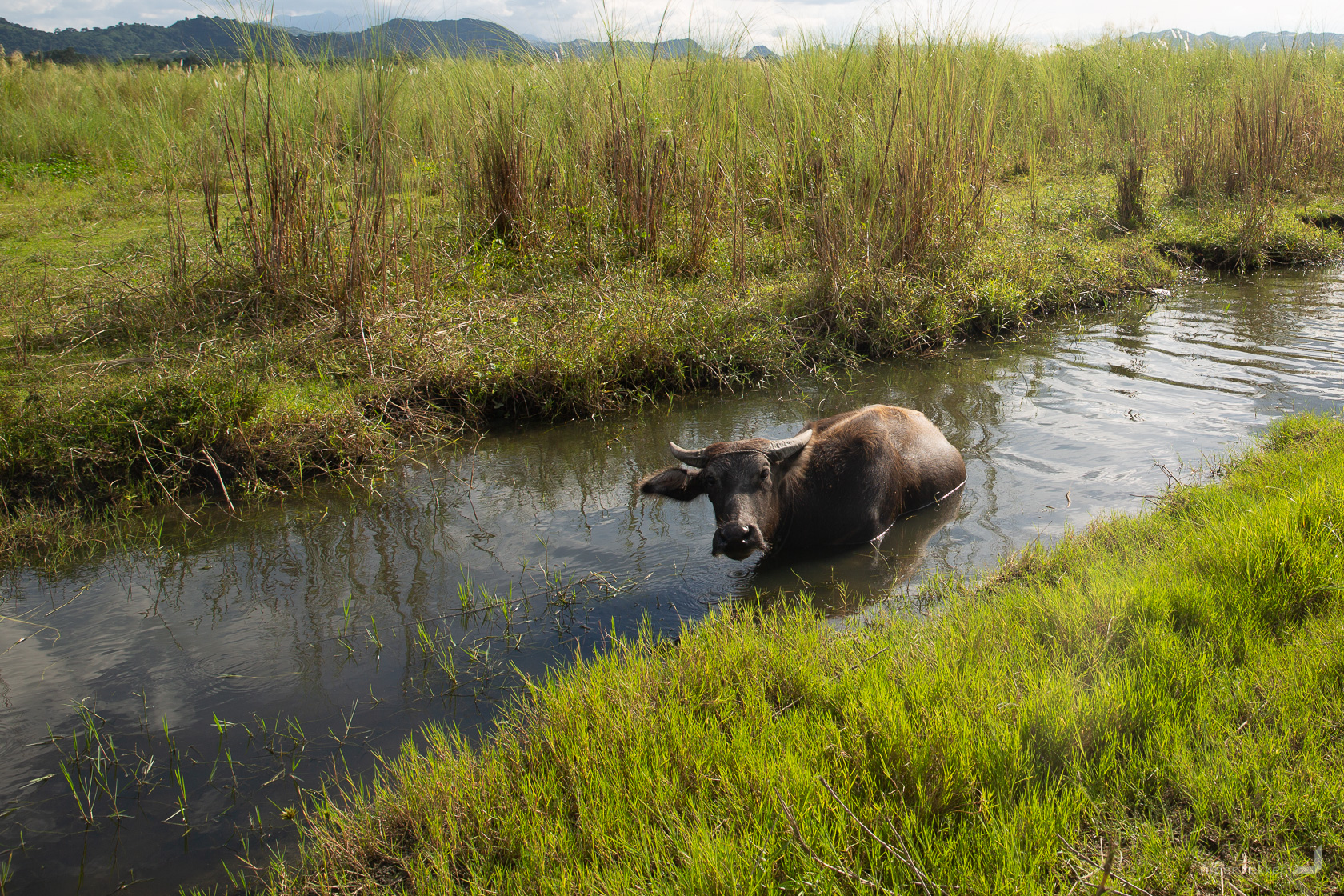
Carabaos are used for nearly everything that requires strength such as plowing the land and transporting heavy goods.
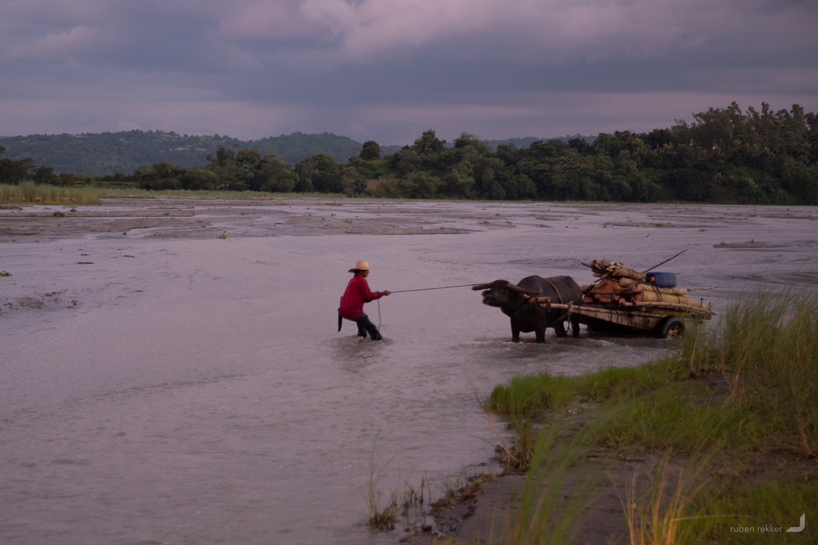
A local farmer tries to encourage a carabao to cross the river.
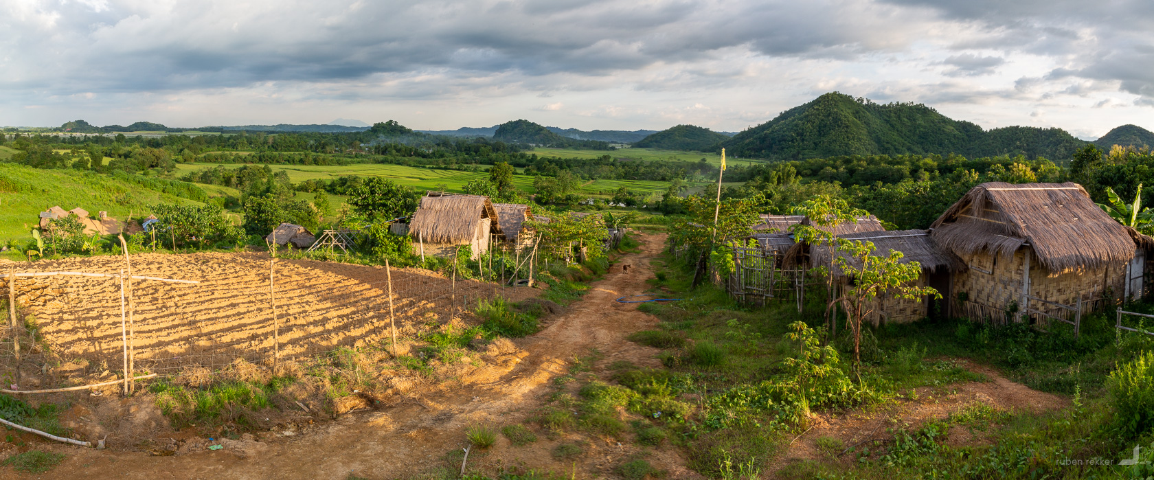
Aeata village near Mount Pinatubo.
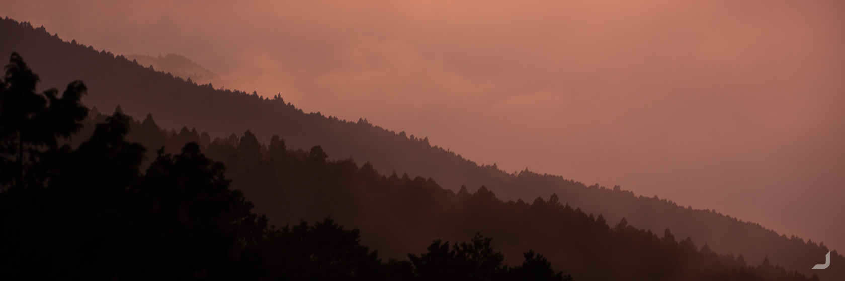
Taiwan
Taipei
My mum usually tries to find time each year to visit me wherever I may be. This year, I had to be in Taiwan for a wedding of one of my best friends. My auntie (her sister) asked if she could come along too. Here I was, exploring and hiking the mountains with two enthusiastic ladies who were eventually classified as officially inexhaustible. Initially with the guidance of a hospitable friend of my sister, we would explore the mountainous area around Nantou County in the middle of the island. But before we left for the mountains, we had a day to explore the capital.
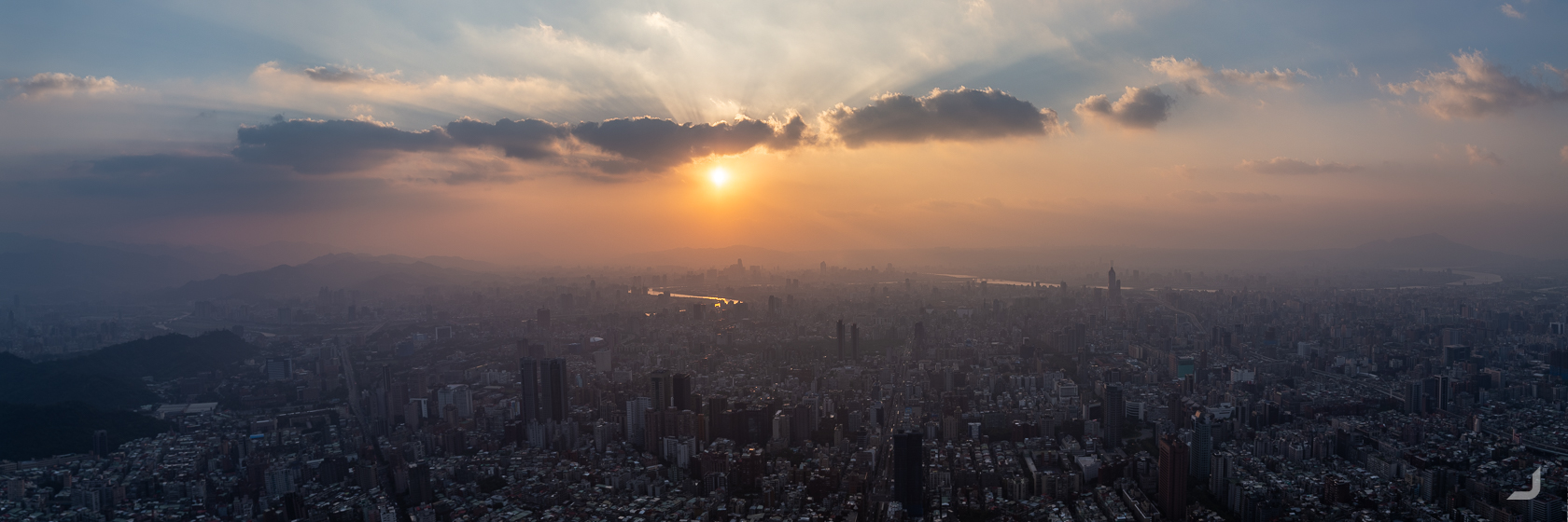
The Taipei 101 tower has 101 floors and was – until the Burj Khalifa in Dubai came along – in 2010 the tallest building in the world.
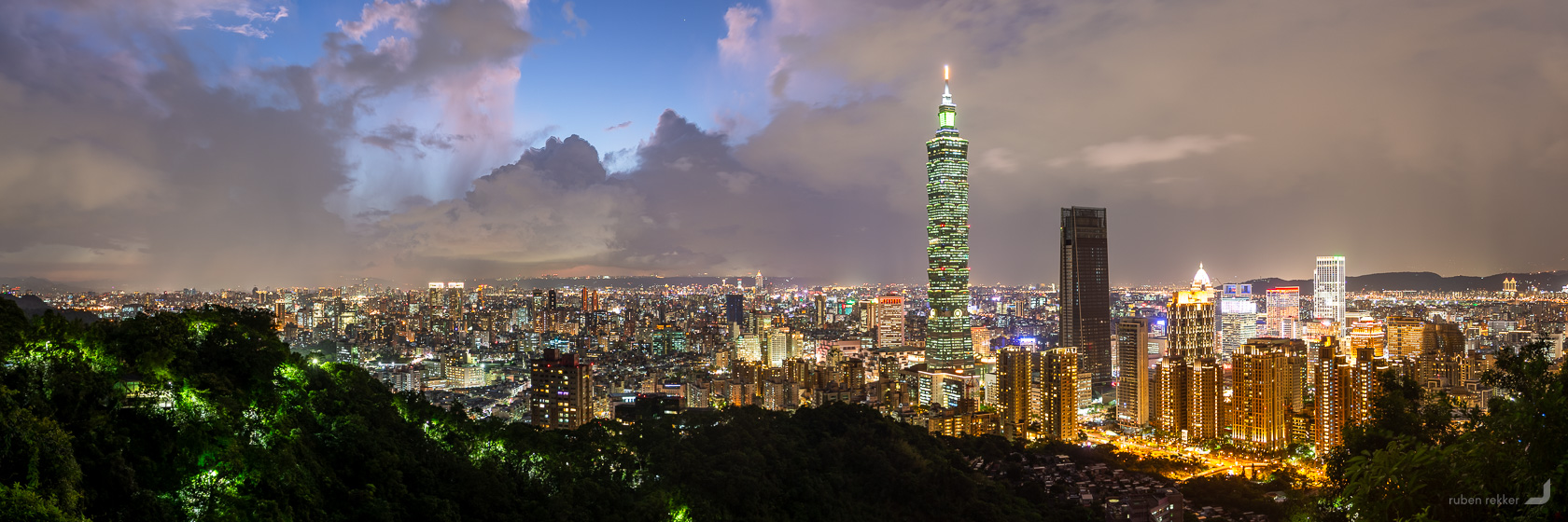
Taipei skyline from the Elephant Mountain in Taiwan.
Xitou
One of the first destinations in the south of Nantou was the Xitou Nature Eduction Area. Inside this park, there is an elevated walking path amongst the tree tops which also functions as a bridge in some places.
Some of these umbrella’s allowed for colourful contrasts amongst the darker surroundings. Yes it was a rainy day, like most days in Taiwan.
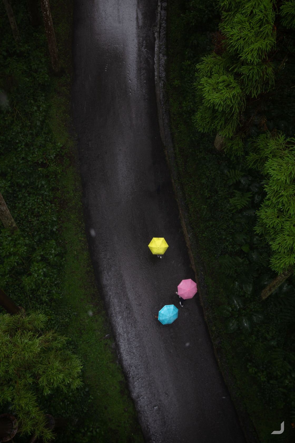
View from a walk bridge inside the Xitou Nature Eduction Area.
If there was one thing that stood out in Taiwan, it was the hospitality from their locals. Some spoke very little English but did whatever they could to help us. When we arrived in Alishan, it was no different. It was already late in the evening and the place seemed quite remotely located. The hotel host asked (well.. hand signalled) whether we had eaten already. After finding out that we hadn’t, she took us in her car and drove us down to a restaurant in the village. There she waited until we were done. At the previous hotel, the owner drove us to the bus stop after we checked out and helped us with buying bus tickets. After making sure we safely got on the right bus, he went back to the hotel. We sat in the bus for a while, waiting for the bus to leave, until the same hotel owner rushingly came into our bus out of breath, with a pair of glasses in his hand. He thought we had forgotten these glasses in the hotel.. but we had to regretfully tell them that they weren’t ours.
Alishan is famous for its morning sea of clouds. However, making it in time for the sunrise meant leaving at 3am, which meant that the day after was likely to become a little less productive – to the displeasure of my mum and auntie. So I had to make do with a day hike and I was still slightly rewarded with a kindof almost sea of clouds underneath the evening sun from a very challenging position.
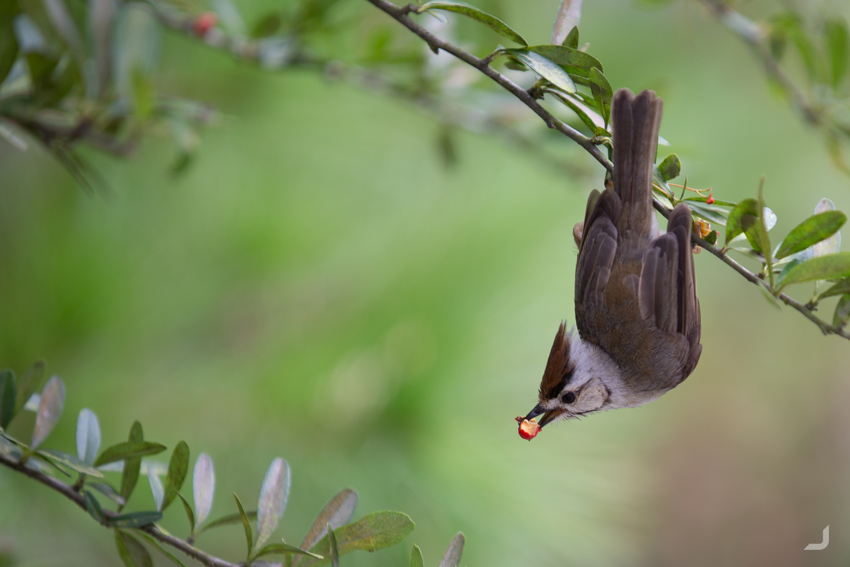
The Taiwan yuhina is a small songbird endemic to Taiwan. They were present in abundance, eating berries and doing what birds do. Like flying.
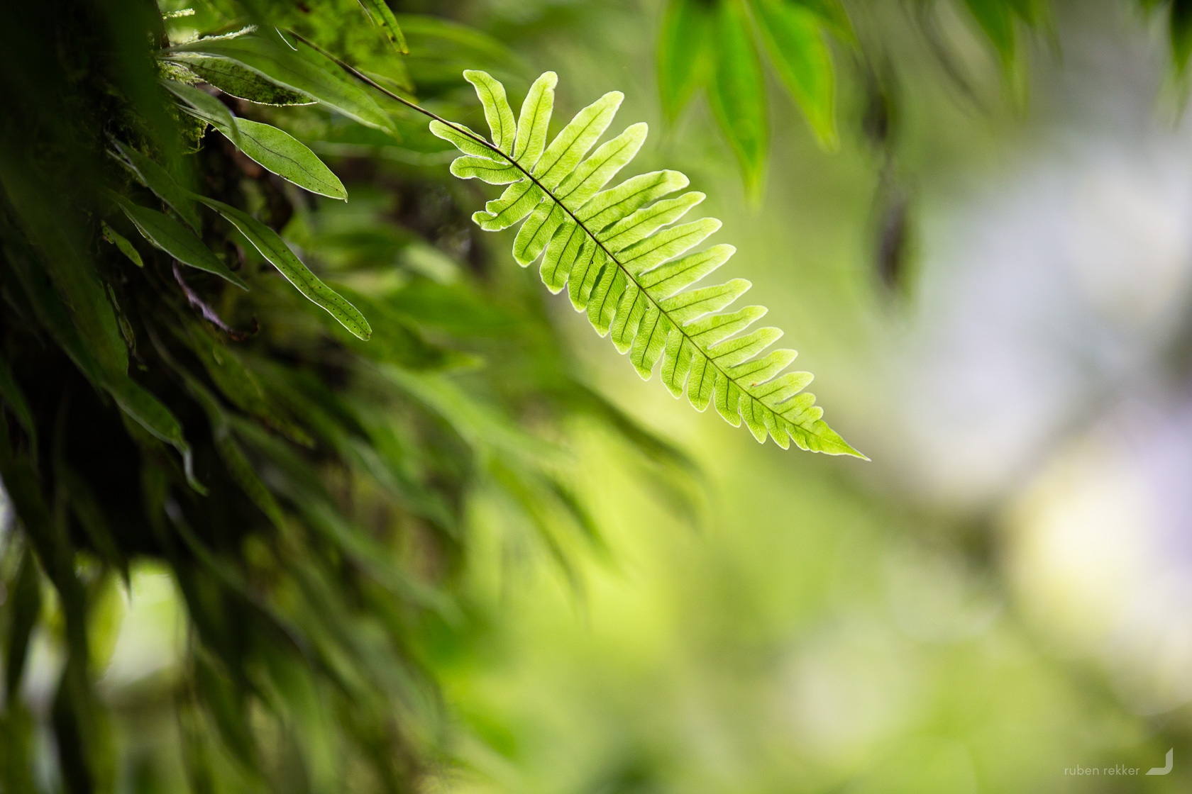
A fern in focus in Taiwan.
The almost sea of clouds from Alishan in Chiayi county.
Taipei
My auntie had received a visit up the Taipei 101 tower as a gift from her children. Unfortunately they could have not foreseen the weather of the pre-booked day of entrance, preventing us from seeing much more than the inside of the viewing deck. After having returned from the mountains we decided to try again, this time being able to see a little more than the colour grey outside.
Being in time for the sunset, the outdoor observation deck provides a full view of the city at an elevation of 391.8 m.
The view from 101st floor inside Taipei 101.
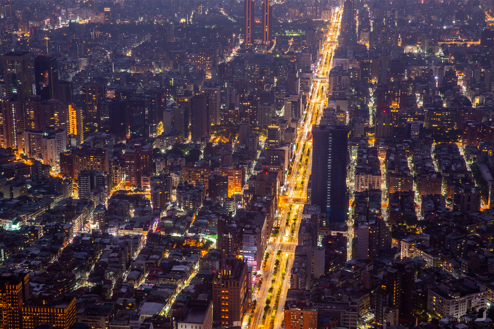
Section 4 of Xinyi Road, taken from Taipei 101.
One of the interesting views inside Treasure Hill, a small art village in the heart of Taipei.
Treasure hill is an art village situated nearby the Tamsui river in the middle of the city. It used to be a residence for retreated veteran solders of the Chinese Civil War and housed about 200 families. After renovations as part of a beautification campaign, it’s become a cool art village with a art studios, galleries, cafes and living spaces for artists. However, only about 20 of those original families were able to move back in causing the need for the others to move elsewhere.
Thailand
Chiang Mai
Returning to Chiang Mai to take photos of the The Yee Peng Festival. It takes place on the full moon of the second month of the Buddhist Lanna calendar. Yee means “two” and Peng means “full moon day”.
In this festival, Khom Loi, Lanna style sky lanterns, are lighted and released into the air. The act of releasing the lantern symbolises letting go of the ills and misfortunes of the previous year. Thousands and thousands of lanterns can be witnessed throughout the night.
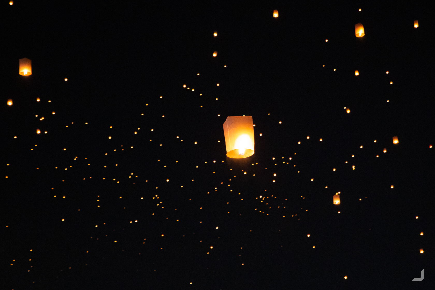
Lanterns floating up into the sky as part of the The Yee Peng Festival in Chiang Mai, Thailand.
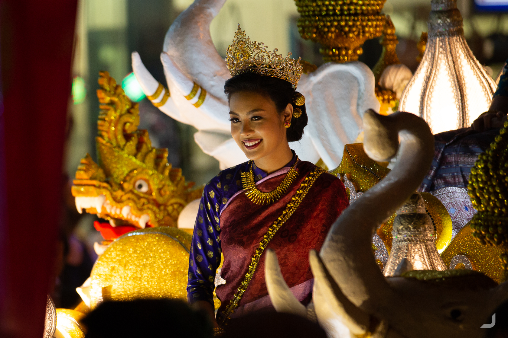
The festival includes a parade called the “Yee Peng Parade”, featuring beauty pageants, that starts around the Tha Phae Gate and follows the road towards the Nawarat Bridge.
Lanterns floating up into the sky as part of the The Yee Peng Festival in Chiang Mai, Thailand.
Mae Sai
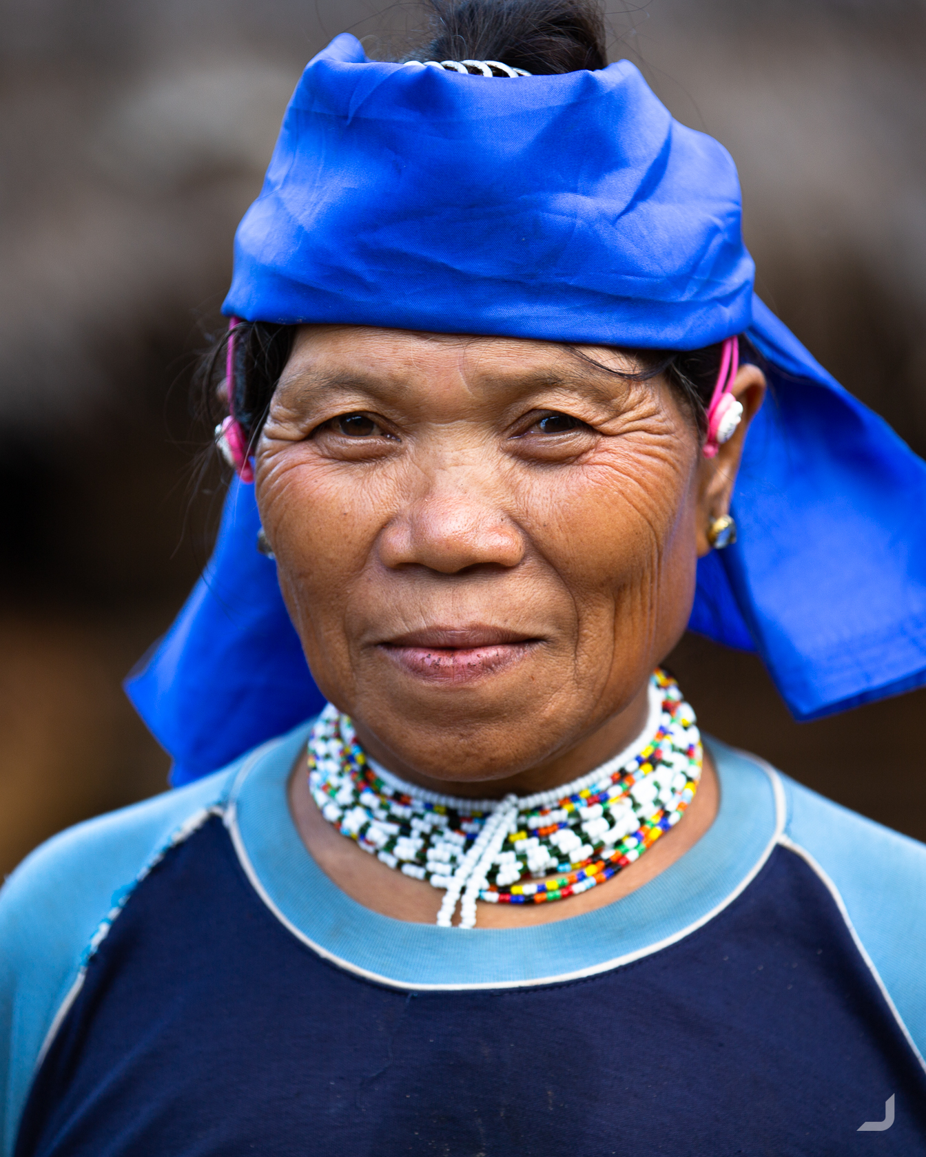
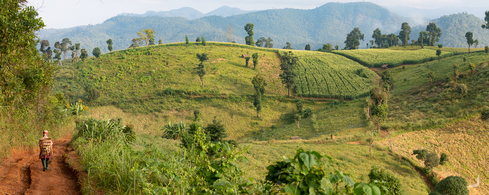
With a few days left in Chiang Mai I commenced on a jungle trek that would lead us down the Mae Hoo river along the east of the Mae Hong Son province, bordering with Myanmar.
We stayed the night in a Poe Karen village and were able to meet some of the local villagers. They are mostly farmers and communication was limited to exchanging smiles and waving hands.
Portrait of a Poe Karen villager.
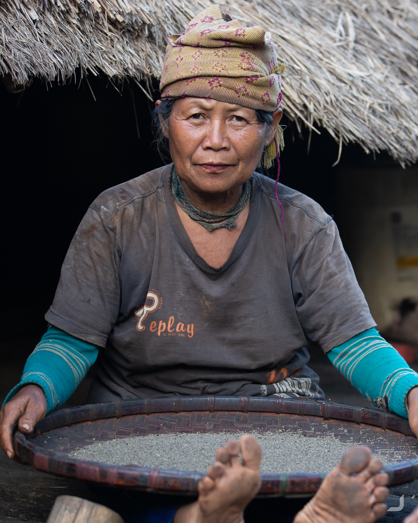
A Poe Karen villager sorts rice in Mae Sai.
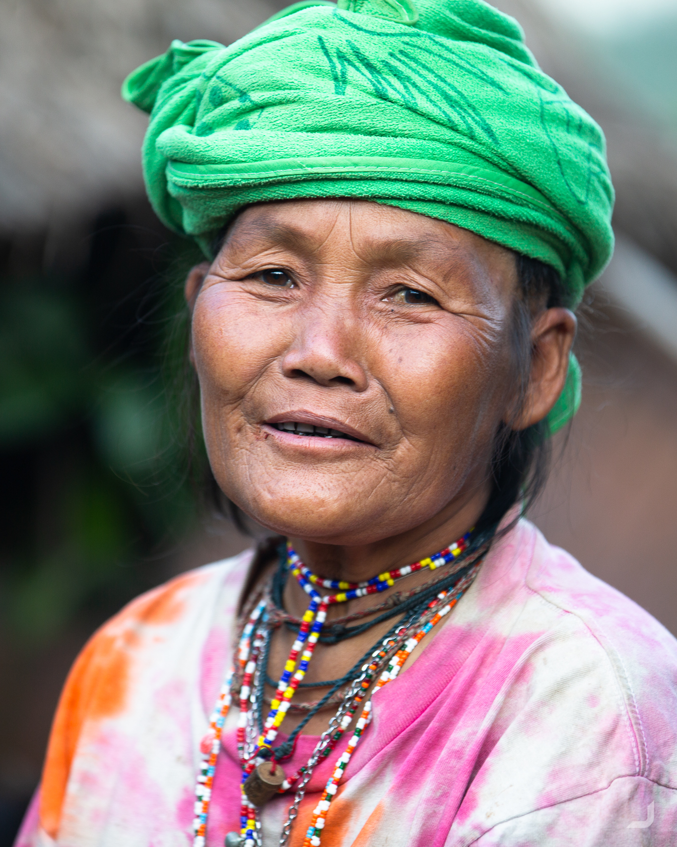
Portrait of a Poe Karen villager.
A Poe Karen villager in Mae Sai.
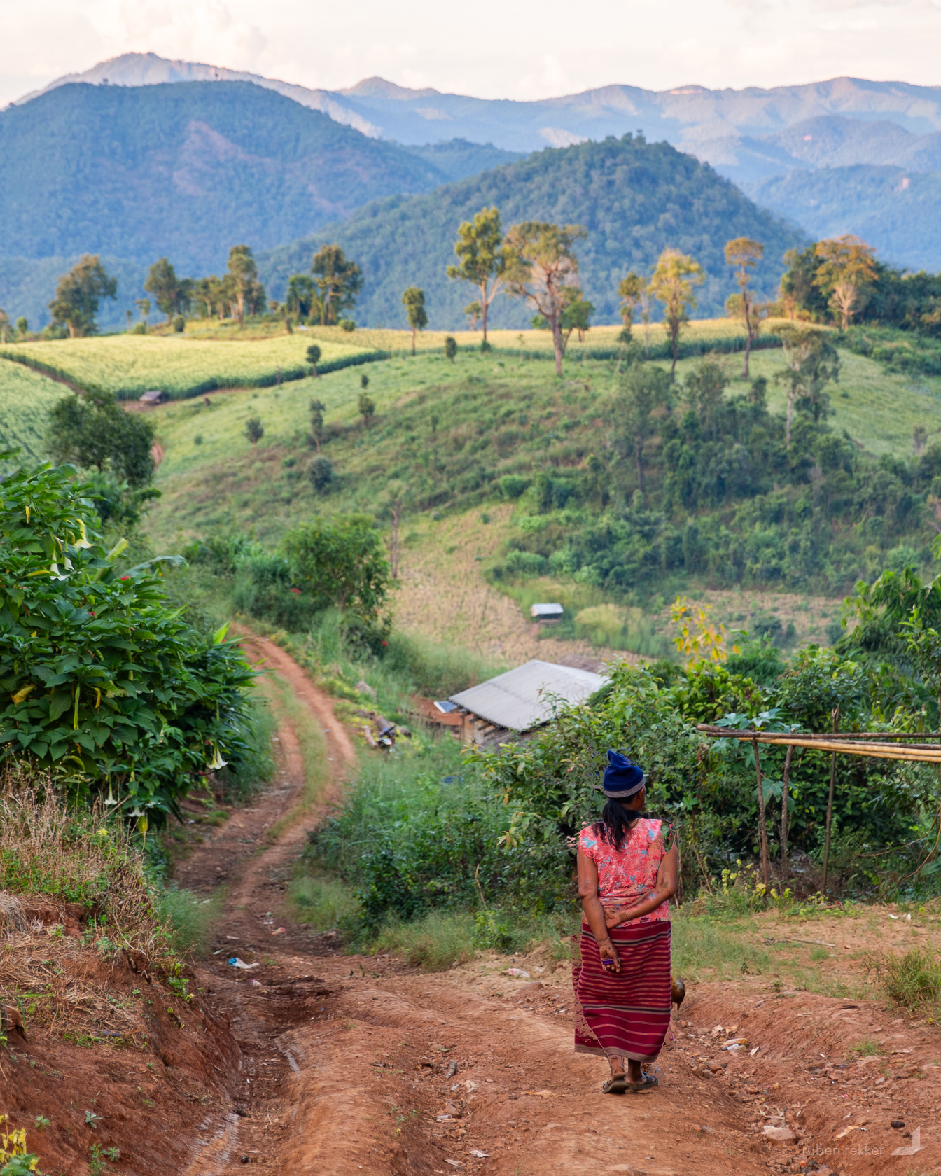
A farmer walks along the scenery of a Poe Karen village in Mae Ho, in the North East of Thailand.
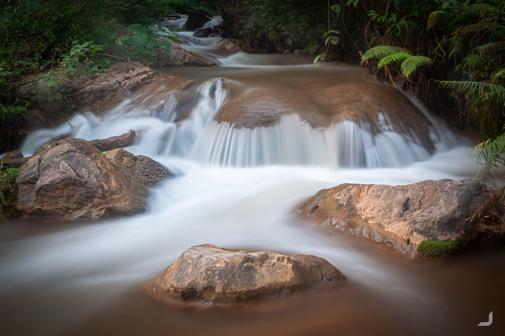
One of the many smaller waterfalls flowing through Mae Sa, Chiang Mai, Thailand.
It would’ve been my last trek before I would return to the Netherlands for my dad’s 70th birthday. For our dinner the next day, our tour guide created cups and cutlery from the bamboo we found along the way. It would’ve been the perfect birthday gift, if not one of my group members (accidentally?) confiscated my set near the end. Luckily I had one bowl left which made it all the way to my dad. Arriving in The Netherlands was the start of spending about 2 months in Europe. I had been home for only 2 weeks in the previous 7 years so it was about time to stop by. Visit the second part “Europe 2018” to view the next series of photos.